Blue Marble Geographics and Alain Olivier Geomatique, Blue Marble’s partner based in France, are pleased to announce that the French Military of Defense (Ministère de la Défense) has signed a three-year agreement to deploy Global Mapper throughout all of branches...
East View Secures Agreement with Norwegian Mapping Authority
East View has obtained the rights to Norway's nationally produced maps and data through an agreement with Kartverket, the Norwegian Mapping Authority. The agreement grants East View access to sell print-on-demand, premium updated Norwegianmapping content, including...
Airbus Defence and Space's PerúSAT-1 Satellite Ready for Take-Off
The PerúSAT-1 satellite, designed and built by Airbus Defence and Space, the world’s second largest space company and world leader in the export of Earth observation satellites, for the Peruvian Space Agency (CONIDA), is ready for launch from the European spaceport...
Trimble Connected Mine Provides Spatial Data Visualization Using Trimble and Microsoft Mixed-Reality Technologies
SUNNYVALE, Calif. —Trimble (NASDAQ:TRMB) announced today the release of its Trimble® Connected Mine™ Visual Intelligence module with support for mixed-reality technology including Microsoft HoloLens to provide visual collaboration of mine spatial data. Trimble...
Avenza Releases Geographic Imager 5.1 for Adobe Photoshop
Toronto, ON - Avenza Systems Inc., producers of the Avenza Maps app for mobile devices and geospatial plug-ins for Adobe Creative Cloud, including MAPublisher® 9.8 for Adobe Illustrator®, is pleased to announce the release of Geographic Imager 5.1 for Adobe...
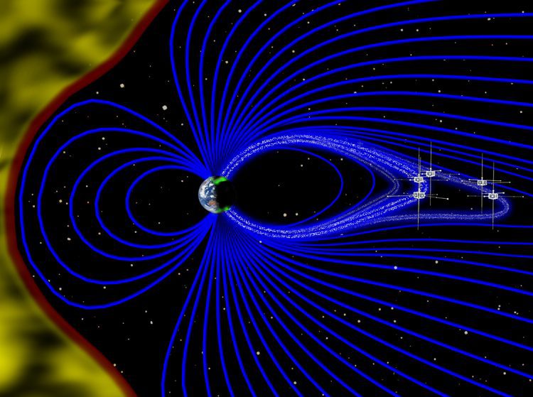
Satellites Record Auroras’ Rhythm
Using data from NASA's Time History of Events and Macroscale Interactions during Substorms (THEMIS) satellites, scientists have observed Earth's vibrating magnetic field in relation to the northern lights in the night sky over Canada.
Teledyne Optech Presenting CZMIL's Object-Detection Capability at Oceans 16 MTS/IEEE
September 13, 2016 — Teledyne Optech is pleased to announce that Chief Scientist Dr. Viktor Feygels will attend the Oceans 16 MTS/IEEE conference in Monterey, California on September 22 to present the object-detection capability of the Optech CZMIL Coastal Zone...
Exprodat Increases Oil & Gas Workflow Integration with Updated Data Assistant
Exprodat, the oil and gas ArcGIS platform specialist, Esri Gold Partner and Getech group company, has released the latest version of its popular Data Assistant software, which simplfies and speeds up the process of importing and exporting common exploration data, to...
Announcing Mapfolio V 2.0 “ Leading free ArcGIS Online Application Gets New Functionality
NASHVILLE, Tenn. — Now, more than ever, Mapfolio lets you navigate and personalize your ArcGIS Online experience with ease. Simplify your search by creating personalized landing pages that filter only the content your users need, allowing them to engage in fewer...
Septentrio Launches New GNSS Receiver for Time and Frequency Transfer Applications
Leuven, Belgium and Torrance, Calif. – Sept. 12, 2016 – Septentrio, a leading provider of accurate and reliable GNSS solutions, today announces the launch of its most advanced GNSS receiver for dedicated time and frequency transfer applications, the PolaRx5TR. The...
