DJI and Datumate have begun offering a drone, software and app package that fully automates and expedites site surveys. Tailored for professional surveying jobs, the DJI-Datumate Site Survey Solution simplifies the surveying and mapping processes, while maintaining...
Teledyne Optech Announces New Efficiency Enhancement for ALTM Galaxy Wide-Area Lidar Mapping Sensor
Teledyne Optech is pleased to announce a high-performance scanner update to its innovative line of airborne laser terrain mappers, the Optech Galaxy ALTM™. The Galaxy’s scan efficiency has been engineered to deliver an additional 30% boost to its class-leading...
InterGEO2016: AltiGator and YellowScan Unveil a 5.6kg Survey-Grade LiDAR UAV all Integrated System, Ideal for Centimetric Urban Surveys
AltiGator and YellowScan are pleased to announce an ultra-light weight LiDAR UAV combo allowing for the first time centimetric UAV surveys in urban areas, in accordance with most regulations. The YellowScan Surveyor ultra-light stand-alone LiDAR system is embedded on...
Pix4D Launches MOBILE + DESKTOP + CLOUD Solutions for Drone Mapping at InterGeo 2016
Drone mapping software developer Pix4D launches hybrid solutions today that integrate mobile, desktop, and cloud platforms for more flexible mapping. “When we started Pix4D six years ago, we were a cloud processing company,†said Christoph Strecha,...
LizardTech Releases Latest GeoExpress, now including Geiger-Mode Support
SEATTLE, Wash. — LizardTech®, the creator of MrSID® and provider of software solutions for managing and distributing geospatial content, today announced the release of GeoExpress® 9.5.3. The company’s flagship image asset handling product to compress,...
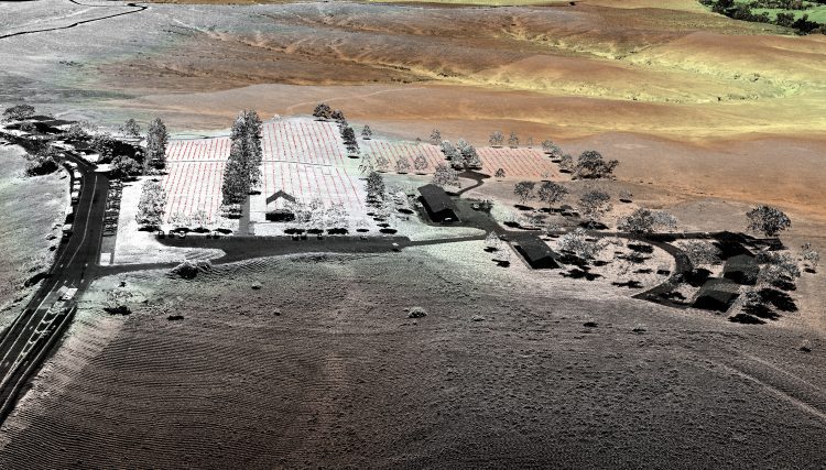
Topographic Lidar Data Employed to Map, Preserve U.S. History
In August 2015, the National Park Service (NPS) contracted Woolpert for the Little Bighorn National Monument Mapping Project to record the locations of thousands of headstone markers at the Custer National Cemetery as well as hundreds of battlefield markers at the Little Bighorn National Monument site, which covers approximately 5.5 square miles.
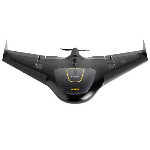
Trimble Sells UAS Business to Delair-Tech
Trimble announced that Delair-Tech acquired its Belgium-based Gatewing Unmanned Aircraft System (UAS) engineering and manufacturing business. Delair-Tech intends to grow the acquired business as part of its portfolio. Financial terms were not disclosed. “This...
SimActive Launches Subscription UAV Software
Montreal, Canada, October 11th, 2016 – SimActive Inc., a world-leading developer of photogrammetry software, is pleased to announce a new subscription-based offering for Correlator3D™ UAV.  The rental option allows users with a dynamic workload to access a...
DigitalGlobe Now Targeting Late October or Early November for WorldView-4 Satellite Launch
WESTMINSTER, Colo. - DigitalGlobe, Inc. (NYSE: DGI), the global leader in earth imagery and information about our changing planet, today announced the WorldView-4 satellite launch has been delayed due to ongoing efforts to restore and test infrastructure at Vandenberg...
Trimble Sells its Unmanned Aircraft System Business to Delair-Tech
SUNNYVALE, Calif., Oct. 10, 2016 —Trimble (NASDAQ: TRMB) announced today that Delair-Tech has acquired its Belgium-based Gatewing Unmanned Aircraft System (UAS) engineering and manufacturing business. Delair-Tech is a leading provider of long-range, fixed-wing UAS...
