HUNTSVILLE, Ala. -Â Oncor Electric Delivery Company (Oncor) has selected Hexagon Safety & Infrastructure to deliver geospatial data across the company's operations. Hexagon's geographic information system (GIS) and network modelling solution will coordinate with...
Rwanda Forges Forward in Drone Mapping Use
After Rwanda made waves in the news early last year for allegedly being the first country to approve drone delivery, people payed attention. The country, with its rolling hills and one of the fastest growing economies in Central Africa has already established...
Leica Geosystems Wins Prestigious PRISM Award and Geospatial World Innovation Award
Heerbrugg, Switzerland; 2 February 2017 – Leica Geosystems, a global leader of measurement and reality capture technology, today announced it has won both the 2017 PRISM Award for Photonics Innovation and the 2017 Geospatial World Innovation Award. The 2017 PRISM...
Planetek Italia Joins Deimos Imaging Reseller Network
Planetek Italia is very glad to announce that is now an authorized distributor of Deimos Imaging, high-resolution world imagery solutions to customers in Italy. With this agreement, Planetek Italia will enrich its capacity to offer remotely sensed satellite products...
TCarta Marine and Proteus Geo Announce Merger to Provide Comprehensive Bathymetry and Marine Mapping Solutions
DENVER, Colorado, USA – TCarta Marine LLC of Denver, Colo., has merged with Proteus Geo of Oxford, UK, to create a global mapping company that provides bathymetric and marine data sets from the shallow coastal zone out to the continental shelf. The new company is...
Siemens and Bentley Systems Agree to Jointly Offer Planning and Design Solutions for Utilities
SAN DIEGO - Building on the strategic alliance between Siemens and Bentley Systems that was made public in November 2016, Siemens’ Energy Management Division and Bentley Systems have announced an agreement to jointly develop solutions to accelerate digitalization of...
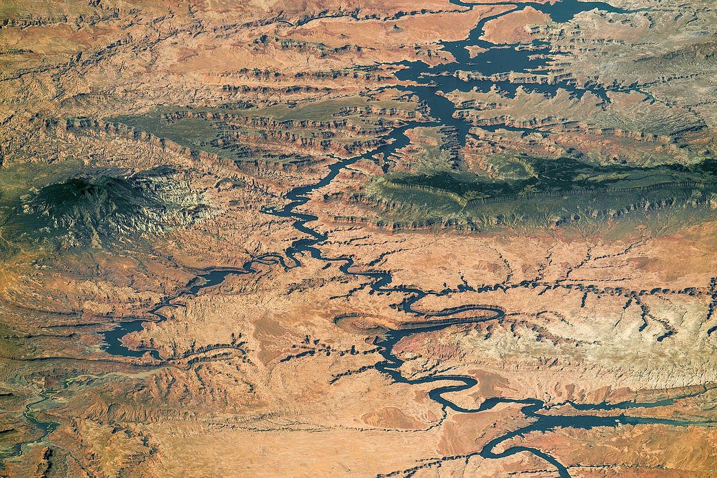
Space Station Astronaut Photographs Full Length of Lake Powell
A panorama photograph taken by an astronaut aboard the International Space Station shows nearly the full length of Lake Powell, the reservoir on the Colorado River in southern Utah and northern Arizona.
International Symposium on Digital Earth & Locate17 Showcases Geospatial's Enabling Role in Digital Transformation
Sydney, Australia – 1 February 2017 – Geospatial data’s enabling role in digital transformation will be on show at the International Symposium on Digital Earth & Locate17 in Sydney in April, combining one of the world’s most prestigious symposiums with...
GeoSLAM Launches Desktop V3
GeoSLAM Desktop V3 builds on the success of the popular local desktop version of their SLAM processing software that was released at the start of 2016. Whilst maintaining the simplicity and ease of use of the initial software, V3 now provides users with increased...
The Getech Group Brings Greater Insight to Myanmar's Geology
Getech, providers of natural resources exploration data and information expertise, has released an informative and in-depth report aimed at providing insight into the geology of Myanmar and the surrounding regions.  Regional Reports, written by Getech’s expert...
