Fiery lava continues to pour from the Kilauea volcano on Hawaii's Big Island. These Copernicus Sentinel-2 images from May 23, June 7, and June 12, 2018, show the relentless flow of lava and clouds of ash.
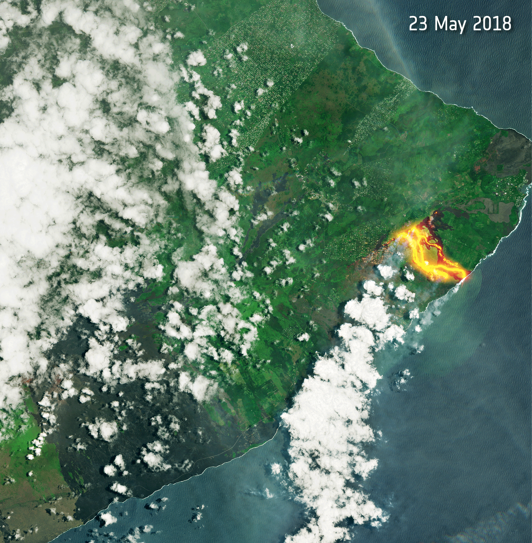
Fiery lava continues to pour from the Kilauea volcano on Hawaii's Big Island. These Copernicus Sentinel-2 images from May 23, June 7, and June 12, 2018, show the relentless flow of lava and clouds of ash.

Over the years, scientists have captured spectacular photographs while mapping ice during NASA's Operation IceBridge mission
Los Angeles, CA –NorthSouth GIS LLC (NSGIS) and Traverse City, Michigan based InfoGeographics, Inc (IGI) have entered into a strategic partnership in the geospatial consulting and systems integration field. Headquartered in Los Angeles, NSGIS has been providing...
REDLANDS, Calif.- Esri, the global leader in spatial analytics, and DigitalGlobe today announced that they have created a Story Map of high-resolution imagery that visualizes the 12 venues being used for 2018 FIFA World Cup Russia, exclusive to The Associated Press....
SAN DIEGO, June 15, 2018 - Kratos Defense & Security Solutions, Inc. (Nasdaq:KTOS), a leading National Security Solutions provider, announced today that its Kratos RT Logic subsidiary won an award for the Pilot Phase 2 program. This effort will implement a...
Nashville, TN - Drones have become one of the hottest electronics in 2018. They can be used for varying purposes, from casual drones for recreational use to high-tech drones for military missions. Valor Drones was established with a vision for transforming the...
MOUNTAIN VIEW, Calif., - Orbital Insight, the leader in geospatial analytics, today announced an exclusive agreement to bundle its products with the Emergency Flood Mapping Services of e-GEOS (ASI/Telespazio) for the U.S. government. This partnership provides...
NEW YORK — InterDrone, The International Drone Conference and Exposition, announced today it has further expanded its drones in Public Safety content with the addition of a full-day Public Safety workshop on Tuesday, Sept. 4, as well as dedicating an entire track to...
SAN DIEGO - Kratos Defense & Security Solutions, Inc. (Nasdaq:KTOS), a leading National Security Solutions provider, announced today that its Unmanned Systems Division (USD) recently received a sole source single award engineering services contract with a maximum...
Calgary, Canada - Hexagon’s Positioning Intelligence division has successfully deployed TerraStar X Global Navigation Satellite System (GNSS) correction technology, which enables instant lane-level accuracy, ideal for autonomous automotive planning programs. In...
