REDLANDS, Calif.—June 6, 2019—Esri, the global leader in geographic information system (GIS) technology, today announced its partnership with the E.O. Wilson Biodiversity Foundation and will be providing the mapping and analytics capabilities...
RegioGraph LocationAdvice: On-the-go Business Site Analyses
GfK releases new online geomarketing tool Bruchsal, Germany, June 6, 2019 – GfK’s newly released online tool RegioGraph LocationAdvice allows expansion and location planners to carry out location and competitor analyses on digital maps while traveling or away from...
NSR Report Assesses Viability for Satellite Constellations Worldwide
CAMBRIDGE, Mass., June 05, 2019 - NSR’s industry standard report on the market for and viability of satellite constellations worldwide: Satellite Constellations: A Critical Assessment, 2nd Edition, releases today. The report provides a complete assessment of key...
Geographic Calculator 2019 SP1 is Now Available
Now in its 27th year of development, Geographic Calculator is widely recognized as the industry leader for accurate coordinate and datum management and has become the go-to application for countless companies and organizations for whom locational precision is...
Virtual Surveyor Unveils Terrain Lenses in Drone Mapping Software
LEUVEN, Belgium – Virtual Surveyor has unveiled Terrain Lenses in Version 6.3 of its popular drone surveying and mapping software. Overlaid on a LiDAR point cloud or orthophoto, the six lenses enhance different aspects of the terrain in 3D to give users a better...
Sofradir and ULIS become Lynred
Veurey-Voroize, near Grenoble, France – Sofradir and its subsidiary ULIS today announce their merger and new company name: Lynred. Lynred was created to respond to a need for an all-inclusive infrared (IR) product offering to the global aerospace, defense,...

An EPIC View of Smoke Over Canada
Smoke from several large wildfires in Canada was so thick and widespread that it was easily visible from 1.5 million kilometers (1 million miles) away from Earth.
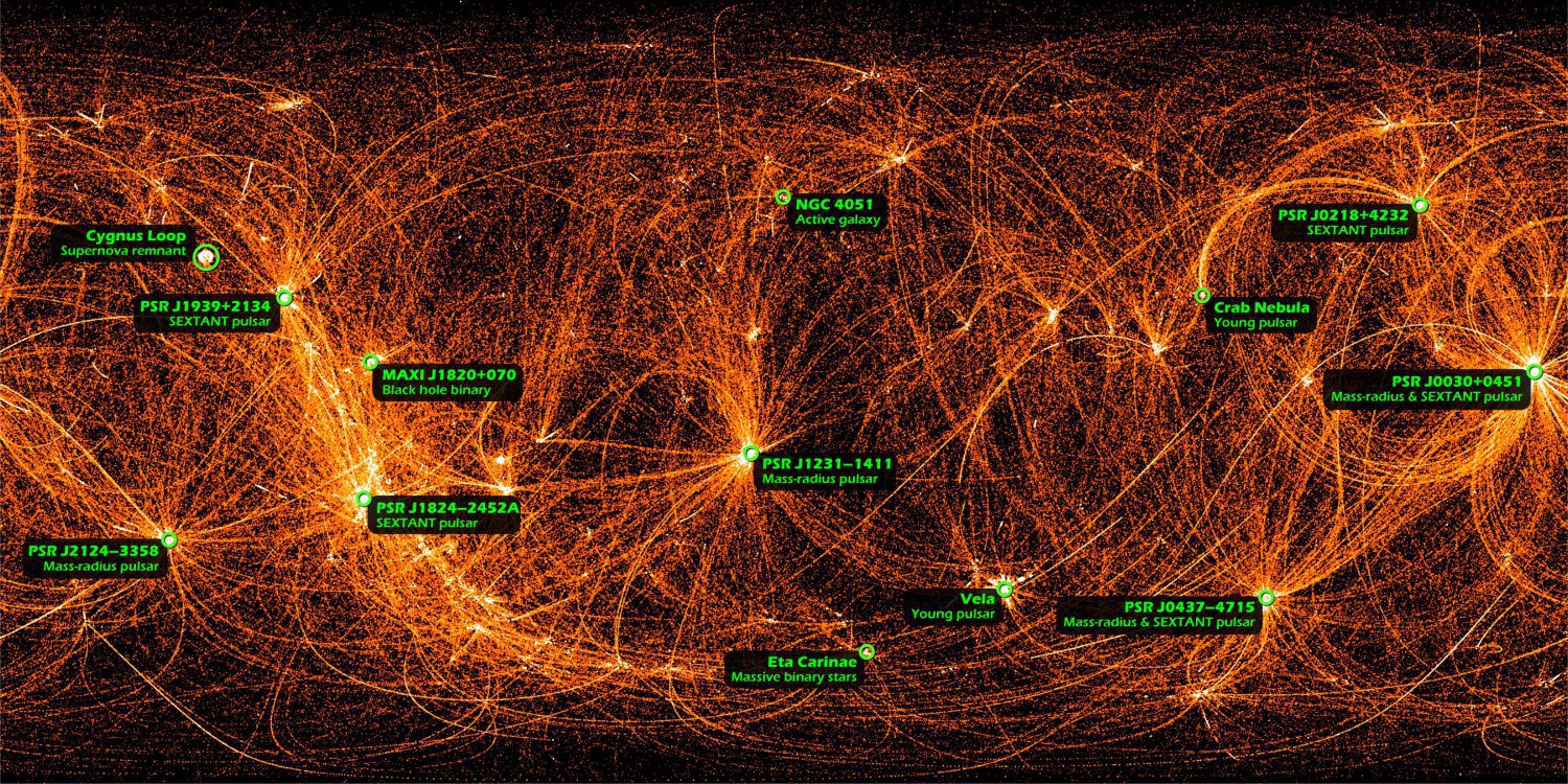
NICER's Night Moves Trace the X-ray Sky
This is a map of the entire sky in X-rays recorded by NASA's Neutron star Interior Composition Explorer (NICER), a payload on the International Space Station.
SimActive Releases Version 8.2 for Processing of Multispectral Imagery
Montreal, Canada, June 4th, 2019 – SimActive Inc., a world-leading developer of photogrammetry software, announces the release of Correlator3D™ version 8.2 with advanced processing capabilities of multispectral imagery.  Supported sensors include the MicaSense...
Kleos to showcase at International GEOINT 2019 Symposium
Kleos Space S.A. (ASX: KSS, Frankfurt: KS1), a space-powered Radio Frequency Reconnaissance data provider, will exhibit at United States Geospatial Intelligence Foundation’s (USGIF) GEOINT 2019 Symposium (GEOINT) at the Henry B Gonzalez Convention Centre in San...
