Intermap Technologies (“Intermapâ€), a global leader in geospatial intelligence solutions, today announced the launch of its Lido Surface Data NEXTView (“NEXTViewâ€) data solution, co-developed with Lufthansa Systems, for the Unmanned Aircraft Systems (UAS)...
Esri Selected to Join Group on Earth Observations as Associate Member Organization
REDLANDS, Calif.- Esri, the global leader in location intelligence, today announced its membership in the Group on Earth Observations (GEO). The new GEO Associates category allows commercial and nongovernmental entities to apply to join existing member institutions in...
Pix4D reaches new heights with an office in the Mile High City
Lausanne, Switzerland: In August 2019, Pix4D opened a new office in downtown Denver. It is the company’s seventh office after Lausanne, San Francisco, Shanghai, Berlin, Madrid, and Tokyo. The move to Denver signifies Pix4D’s strong commitment and alignment with...
Maxar Technologies Awarded Four-Year Global EGD Contract by the U.S. Government for On-Demand Access to Mission-Ready Satellite Imagery
WESTMINSTER, Colo.- Maxar Technologies (NYSE:MAXR) (TSX:MAXR), a trusted partner and innovator in Earth Intelligence and Space Infrastructure, today announced that it has been awarded a new, four-year contract with the U.S. National Geospatial-Intelligence Agency...
Florida's Jackson County Chooses DATAMARK to Solve NG9-1-1 GIS Challenges in Wake of Natural Disaster
TALLAHASSEE, Fla.- Rural Jackson County, Florida selected DATAMARK VEP for its geographic information systems (GIS) and Next Generation 9-1-1 (NG9-1-1) solution, along with technical services from DATAMARK in a $162,000 12-month contract, with annual renewal...
Avineon Joins Esri Partner Network Gold Program
MCLEAN, Va.- Avineon, Inc. (Avineon), a global provider of information technology and engineering support, has participated in the Esri Partner Network since 2002 and today announces an upgrade to the Esri Partner Network Gold Program. As an Esri Gold Business Partner...
6D.ai Lays The Foundation to Build 3D Map of The World
6D.ai (6D), the startup building a 3D map of the world using just a smartphone camera, announced today its commercial availability for developers to begin shipping their applications. Additionally, 6D announced they are working with Qualcomm Technologies, Inc., to...
AeroVironment Donates 87 Quantix Drones and AV DSS Ecosystems to 35 U.S. University Agriculture Departments to Advance Drones in Farming
SIMI VALLEY, Calif.- AeroVironment, Inc. (NASDAQ: AVAV), a global leader in unmanned aircraft systems for both defense and commercial applications, today announced its 2019 Quantix and AV DSS University Collaboration Project. The project’s focus is to advance...
GA-ASI Receives FAA No-Chase COA for Unmanned Flights in North Dakota
GRAND FORKS – General Atomics Aeronautical Systems, Inc. (GA-ASI) has received a Certificate of Waiver or Authorization (COA) from the Federal Aviation Administration (FAA) for Beyond Visual Line of Sight (BVLOS) operations by utilizing a Ground-based Sense and...
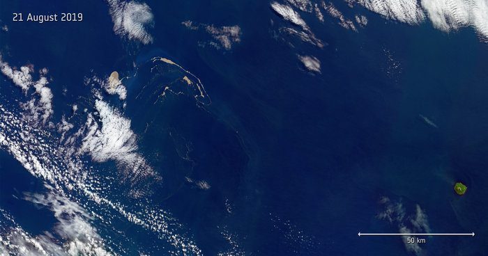
Raft of Rubble
Captured by the Copernicus Sentinel-2 mission on Aug. 21, 2019, this image features a huge raft of pumice rock drifting in the Pacific Ocean.
