PALO ALTO, Calif.- Orbital Insight, the leader in geospatial analytics, today announced the addition of former National Geospatial-Intelligence Agency Director Robert Cardillo and former United States Geospatial Intelligence Foundation CEO Keith Masback as the...
The Industrial Internet Consortium and the Open Geospatial Consortium Announce Liaison
The Industrial Internet Consortium® (IIC™) and the Open Geospatial Consortium (OGC) announced they have agreed to a liaison to work together to advance their shared interests. Under the agreement, the IIC and OGC will work together to align efforts to maximize...
Interdrone 2019: Yuneec Presents the Gimbal-stabilized 4K Quadcopter Mantis G – a New Top Consumer Drone For Outdoor and Social Media Enthusiasts
LAS VEGAS - Today, Yuneec announced a new must-have consumer drone at the Interdrone 2019 in Las Vegas. For all those who want to spice up their social media profiles with unique 4K aerial photos or simply capture breathtaking moments and memories from an exceptional...
Orbit GT opens additional Data Center in western USA
Orbit GT opens an additional Data Center Online totaling 5 Data Centers covering the globe. “Happy to say that a 5th Data Center has been opened to better support our growing customer requestsâ€, says Peter Bonne, CEO of Orbit GT. “The US West Data Center...
Concept3D Platform Selected by Penn State for System-Wide Interactive Campus Maps and Virtual Tours
Concept3D Platform Brings 22 Separate Campuses to Life Online Through Realistic 3D Renderings, Interactive Software, Wayfinding System and Built-In Virtual Tours Concept3D, a leader in creating immersive online experiences with 3D modeling, virtual reality (VR),...
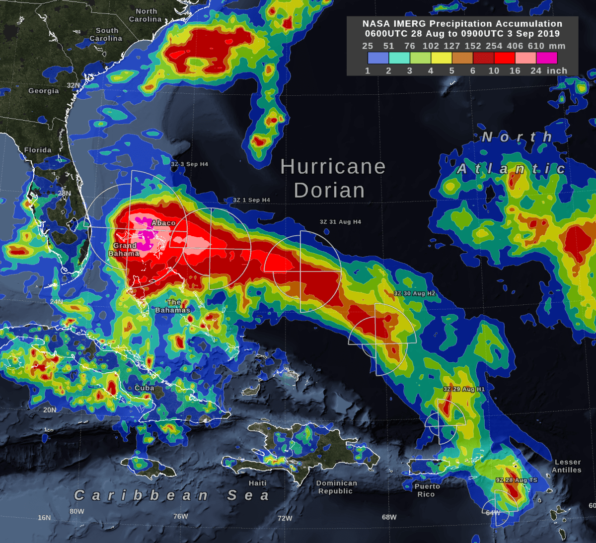
NASA's IMERG Estimates Hurricane Dorian's Rain
Storm-total rain accumulation over parts of Grand Bahama and Abaco Islands exceeded 24 inches, according to NASA satellite-based estimates.

Hurricane Dorian
This Copernicus Sentinel-3 image features Hurricane Dorian as it pummels the Bahamas on Sept. 2, 2019.
Teledyne brings its advanced defense capabilities to DSEI 2019
Teledyne’s Marine, Imaging, Space & Defense, and Engineered Systems groups will display their advanced technologies for land, sea, air, and space in a single, combined booth  Chelmsford, UK — September 3, 2019 — A collective of Teledyne [NYSE: TDY]...
Woolpert and iXblue Partner to Deliver Aerial Mapping Services to Australia, New Zealand and the South Pacific
ARLINGTON, Va. (Sept. 3, 2019) — Woolpert and iXblue Sea Operations division, part of iXblue Group based in France, have formed a strategic partnership to provide aerial mapping services to clients in Australia, New Zealand and across the South Pacific. The pairing...
Teledyne Optech to preview new Compact Airborne and Mobile Lidar Solutions at INTERGEO 2019
Vaughan, ON, Canada — September 3, 2019 — Teledyne Optech, a Teledyne Technologies [NYSE:TDY] company, is poised to make an impact at InterGEO during its 45th Anniversary this year with new technologies in airborne, mobile and compact lidar solutions....
