By Guy Thomas, science and technology advisor, U.S. Coast Guard (www.uscg.mil), Washington, D.C. If oil is the world’s lifeblood, then oceanic commerce is its backbone. Since the 9/11 attack on the United States, many national and international organizations have...
Searching for Seafaring Needles in a Huge Haystack
The most critical part of an ocean or sea in terms of a country’s economic prosperity is its exclusive economic zone (EEZ), which basically is the area of water extending 200 nautical miles outward from a nation’s coastline. A host of economic activities,...
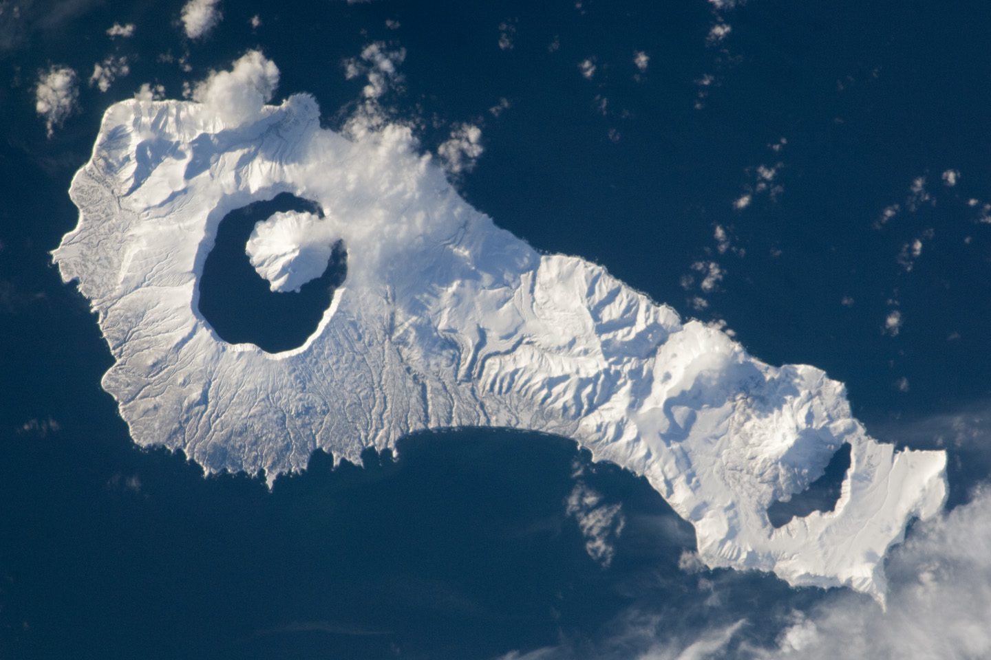
Onekotan Island, Kuril Islands, Russian Federation
Snow cover highlights the calderas and volcanic cones that form the northern and southern ends of Onekotan Island, part of the Russian Federation in the western Pacific Ocean. Calderas are depressions formed when a volcano emptiesits magma chamber in an explosive...

Tassili n'Ajjer National Park
Tassili n’Ajjer National Park covers 72,000 square kilometers (27,800 square miles) in southeastern Algeria. Part of the Sahara Desert, the park has a bone-dry climate with scant rainfall, yet does not blend in with Saharan dunes. Instead, the rocky plateau rises...
Transportation Management: LiDAR, Satellite Imagery Expedite Infrastructure Planning
By Waheed Uddin, professor of civil engineering and director, Center for Advanced Infrastructure Technology (www.olemiss.edu/projects/cait), University of Mississippi, University, Miss. For years, transportation projects have benefitted from aerial photography and...
Imagery In the News
Astronaut's Lens Reveals Australia Floods
NASA Satellites Capture a Stronger La Nińa
NASA Satellites Capture a Stronger La Nińa A new Ocean Surface Topography Mission (OSTM)/Jason-2 satellite image of the Pacific Ocean indicates the current La Nińa event in the eastern Pacific remained strong during December 2010. "This latest event appears to be...
Industry Updates
NASA Satellites Capture a Stronger La Nińa
A new Ocean Surface Topography Mission (OSTM)/Jason-2 satellite image of the Pacific Ocean indicates the current La Nińa event in the eastern Pacific remained strong during December 2010.
“This latest event appears to be one of the strongest ones over this time period,” says Climatologist Bill Patzert of NASA’s Jet Propulsion Laboratory. “It’s already impacting weather and climate all around the planet.”
FEATURE EXTRACTION: Approaching Near Real-Time Mapping Solutions for Geointelligence
The ability to derive intelligence from airborne or satellite-based sensors in an automated or semi-automated way offers numerous advantages for government and relief agencies responding to global disasters and conflicts. It is also a key element in an early response...
DATA SHARING: Mexico City Increases Emergency Response Capacity
On Sept. 19, 1985, Mexico City experienced one of the most devastating earthquakes in history. The magnitude 8.1 quake shook the city in two separate tremors, burying more than 10,000 people amid the rubble. Mexico City officials and citizens commemorate the event by...
