By Robert Simmon, NASA Goddard Space Flight Center (www.nasa.gov/goddard), Greenbelt, Md. hen it comes to misinterpreting a satellite image or map, there are many ways the media and other organizations can get it wrong. For example, consider this recent headline and...
Modeling the World
Image processing innovations are creating value for decision makers. By Robert Schowengerdt, professor emeritus, University of Arizona (http://www.arizona.edu/), Tucson, Ariz. He is the author of Remote Sensing—Models and Methods for Image Processing (2006), which...
Data Fusion Expands Intelligence Options
By James. S. Blundell, vice president, Geospatial Products and Solutions, Overwatch Systems (http://www.overwatch.com/), Sterling, Va. Remote sensing, in all its varied forms and functions, has continually evolved, from the Civil War-era fixed balloons with spotters...
The Great Grain Robbery: Lessons Learned from Earth Imaging's Early History
By Dr. Gary E. Weir, historian, National Geospatial-Intelligence Agency (http://www.nga.mil/), Bethesda, Md. Have you ever heard of the Great Grain Robbery of 1972? What sounds like a train hijacking actually opened the intelligence community’s eyes to the...
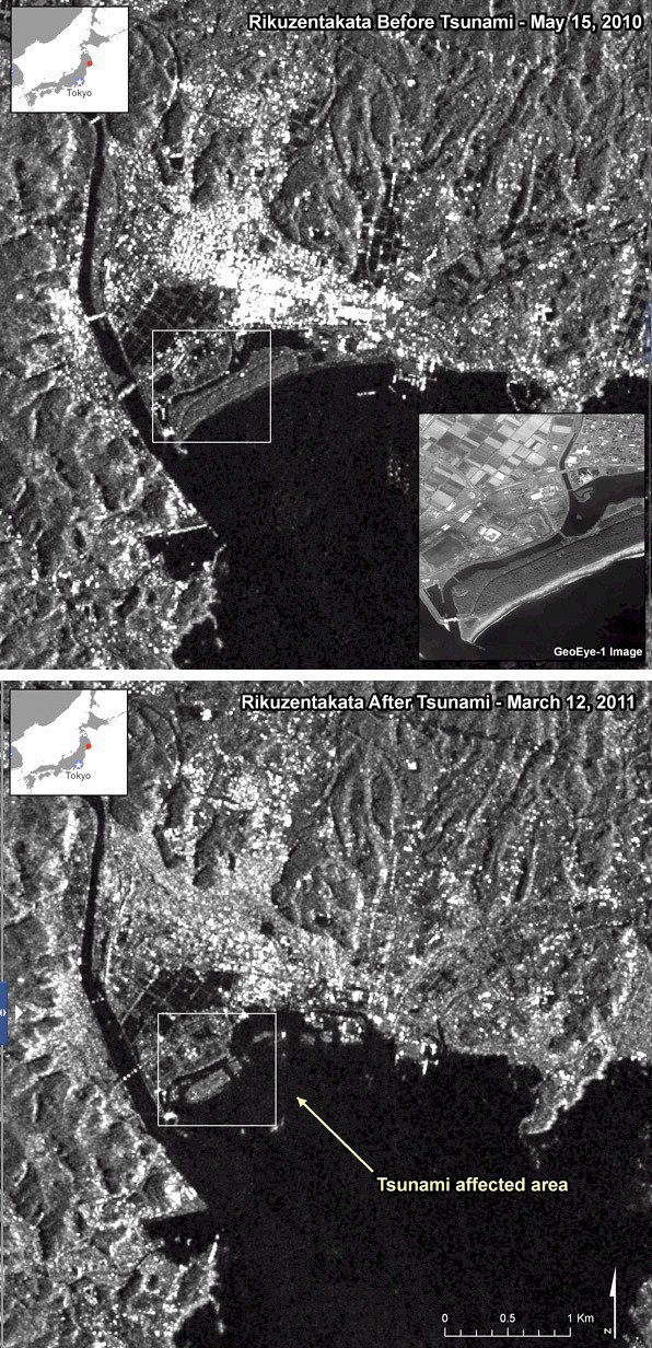
Keeping an Eye on Asia
Following the March 11, 2011, tsunami that ravaged Japan’s coastline, the geospatial community has rallied around the country, providing disaster response tools on the ground and an array of geospatially based information resources via the Internet. Japan continues...
Air Combat Command's GeoBase Mission
Advanced raster management speeds disaster response and other mission-critical data to U.S. Air Force operations worldwide. By Mike Cannon, Dave Williams and Matt Moore, AECOM (http://www.aecom.com/), Virginia Beach, Va. The U.S. Air Force (USAF) is divided into Major...
Immediate Awareness Immediate Response
New Web-based platforms for delivering satellite imagery and other critical geospatial information to first responders are revolutionizing disaster management. By Tara Byrnes, director, North American channel, GeoEye (http://www.geoeye.com/), Herndon, Va. Sometimes we...
Disaster Response in JAPAN
Geospatial Community to the Rescue Following the devastating March 11, 2011, earthquake and tsunami that struck Japan, a host of geospatial companies provided pivotal disaster response information and services. Many of the same companies and more will contribute to...

Sensor-Knowledge System Protects Critical Infrastructure
Threat Detection and Assessment A development team led by TerraEchos and its sister company, GCS Research, both of Missoula, Mont., have introduced a commercial sensor-knowledge system capable of detecting, locating and classifying threats to remote high-risk...
Earth-Mapping Shuttle Mission Marks 10th Anniversary
The data benefit scientists, engineers, government agencies and the public with applications that range from land-use planning to virtual Earth exploration. NASA is currently using Shuttle Radar Topography Mission data to create an even better global topographic map...
