The NOAA satellite GOES-16 captured this geocolor image of Hurricane Irma passing the eastern end of Cuba at about 8:00 a.m. EDT on Sept. 8, 2017.
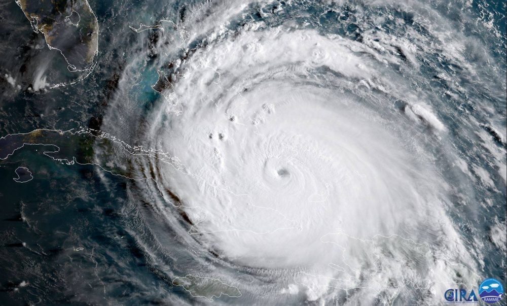
The NOAA satellite GOES-16 captured this geocolor image of Hurricane Irma passing the eastern end of Cuba at about 8:00 a.m. EDT on Sept. 8, 2017.

NASA-NOAA's Suomi NPP Satellite provided a night-time and infrared look at Hurricane Irma, revealing the power under the clouds. NASA's GPM also provided a look at the rainfall being generated by the storm.

NASA upgraded its Earth Polychromatic Imaging Camera (EPIC) imagery website that provides daily views of Earth from 1 million miles away, now allowing the public to choose natural or enhanced color images of Earth as well as zoom into an area on the globe.
GOES-16, the first spacecraft in NOAA's next-generation of geostationary satellites, sent back to Earth the first high-resolution images from its Advanced Baseline Imager (ABI) instrument.
MELBOURNE, Fla. - The National Oceanic and Atmospheric Administration (NOAA) has released the first image taken by Harris Corporation’s (NYSE:HRS) Advanced Baseline Imager (ABI) onboard their next-generation weather satellite. The image taken from the Geostationary...
NOAA Research today announced $6 million in funding to get scientific and technological advances from the government and academia to NOAA’s National Weather Service (NWS) more rapidly, improving severe weather and water hazards forecasting. “NOAA has sharpened its...
REDLANDS, Calif. — Esri, the world leader in geographic information system (GIS) technology, today announced its participation in the Weather-Ready Nation Ambassador initiative. Recognized by the National Oceanic and Atmospheric Administration (NOAA) to protect US...
NORCROSS, GA – Quantum Spatial, Inc., the nation’s largest independent geospatial data firm, announced today that the company will be acquiring, processing and delivering high-resolution aerial LiDAR data and multispectral imagery data from an unmanned aerial...
PASADENA, Calif. — Tetra Tech, Inc. (NASDAQ: TTEK) announced today that the National Oceanic and Atmospheric Administration (NOAA) has awarded the Company a $49 million, indefinite delivery, indefinite quantity contract to support the Office for Coastal...
Smart-mapping leader Esri today released a beautiful, robust new collection of Web maps that forecast NOAA stream-flow data throughout the continental U.S.
