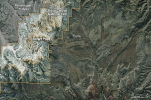
On March 9, 2017, Landsat 8 captured this natural-color image of a snow-covered Bryce Canyon National Park. (Credit: NASA Earth Observatory image by Joshua Stevens, using Landsat data from the U.S. Geological Survey)
Utah's Bryce Canyon is not the deepest canyon in the United States; its largest amphitheater of naturally eroded rock drops 240 meters. Arizona's Grand Canyon, for comparison, measures more than 1,800 meters deep in places. But photographers who visit Bryce Canyon National Park typically aren't looking for dizzying heights and depth; they're often trying to capture images of the delicate spires called hoodoos that rise from the canyon.
This Landsat 8 satellite image collected by its Operational Land Imager shows the north-central part of the park in the vicinity of the main amphitheater. Unlike canyons sculpted primarily by a river, Bryce Canyon is the result of weather-induced erosion. Through time, weathering shaped the hoodoo-filled amphitheaters that descend from the east side of the Paunsaugunt Plateau. Compared to Zion Canyon just 80 kilometers away, Bryce Canyon is about 300 meters higher in elevation, and the climate is cooler and moister.

