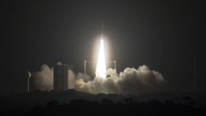
A Vega rocket launched from French Guiana to place the Sentinel-2B satellite in orbit. (Credit: Arianespace)
The European Space Agency (ESA)-developed Sentinel-2B satellite was launched on March 7, 2017, doubling the coverage of high-resolution optical imaging in the Sentinel-2 mission for the European Union Copernicus environmental monitoring system.
The 1.1-tonne satellite was carried into orbit on a Vega rocket from Europe's Spaceport in Kourou, French Guiana. The first stage separated nearly 2 minutes after liftoff, followed by the second stage and fairing at close to four minutes after liftoff, and the third stage at about 6.5 minutes.
After two more ignitions, Vega's upper stage delivered Sentinel-2B into the targeted Sun-synchronous orbit. The satellite separated from this stage nearly one hour into flight.
Telemetry links and attitude control then were established by controllers at ESA's operations centre in Darmstadt, Germany, allowing activation of Sentinel's systems to begin. The satellite's solar panel has already been deployed.
After this first launch and early orbit phase, which typically lasts three days, controllers will begin checking and calibrating the instruments to commission the satellite. The mission is expected to begin operations in 3-4 months.
With this launch, we are taking another step toward advancing the Copernicus program, which is the most sophisticated Earth-observation system in the world, said ESA Director General Jan Woerner. And we are planning to add two more satellites to the constellation in the next months: with Sentinel-5P and Sentinel-3B.
The optical-imaging Sentinel-2 mission is based on a constellation of two identical satellites: Sentinel-2A, which was launched in June 2015, and Sentinel-2B. Although launched separately, the satellites are placed in the same orbit, flying 180 degrees apart. Every five days, the satellites jointly cover all land surfaces, large islands, and inland and coastal waters between latitudes 84°S and 84°N, optimizing global coverage and data delivery.
Each Sentinel-2 satellite carries an innovative high-resolution multispectral camera with 13 spectral bands for a new perspective of land and vegetation. The combination of high-resolution, novel spectral capabilities, a field of vision covering 290 kilometers, and frequent revisit times will provide unprecedented views of Earth.
