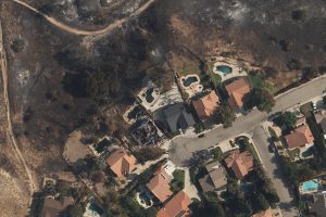
 As evacuation orders lifted and the Saddleridge Fire continued to be contained by the Los Angeles Fire Department, the Geospatial Intelligence Center (GIC) began flying aircraft over the impacted areas, collecting high-resolution aerial images of the damaged structures.
The imagery was made available to GIC members, giving insurers the ability to search an address and view before and after aerial images of properties within the impacted area. These images provide insurers with vital information to better respond and pay claims faster to victims while increasing fraud detection. The imagery is provided at no cost to emergency personnel, first responders, and law enforcement to assist in their response to the damage.
Image Credit: Geospatial Intelligence Center (GIC)
