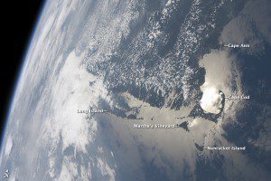
This striking display”often visible to the International Space Station (ISS) crew due to their ability to look outwards at angles between 0 and 90 degrees”is sunglint on the waters of Earth. Sunglint is caused by sunlight reflecting off of a water surface directly toward the observer”much as light reflects from a mirror. Variations in the roughness of the water surface scatter the light, blurring the reflection and producing the silvery sheen of a sunglint area.
The point of maximum sunglint in this image is centered within Cape Cod Bay, the body of water partially enclosed by the hook of Cape Cod in Massachusetts (image right). (The U.S. Congress authorized the creation of Cape Cod National Seashore 50 years ago, in August 1961). Sunglint off the water provides sharp contrast with the coastline and the nearby islands of Martha's Vineyard and Nantucket, both popular destinations for tourists and summer residents. To the north, rocky Cape Ann extends into the Atlantic Ocean; the border with New Hampshire is located approximately 30 kilometers (18 miles) up the coast.
Further to the west, the eastern half of Long Island, N.Y., emerges from extensive cloud cover over the mid-Atlantic and Midwestern States. Persistent storm tracks had been contributing to record flooding in the Midwest at the time this image was taken in late June 2011. Thin blue layers of the atmosphere, contrasted against the darkness of space, are visible along the Earth's curvature at image left.
Astronaut photograph ISS028-E-9979 was acquired on June 27, 2011, with a Nikon D2Xs digital camera using a 28 mm lens and is provided by the ISS Crew Earth Observations experiment and Image Science & Analysis Laboratory, Johnson Space Center. The image was taken by the Expedition 28 crew. The image has been cropped and enhanced to improve contrast. Lens artifacts have been removed. The International Space Station Program supports the laboratory as part of the ISS National Lab to help astronauts take pictures of Earth that will be of the greatest value to scientists and the public, and to make those images freely available on the Internet. Additional images taken by astronauts and cosmonauts can be viewed at the NASA/JSC Gateway to Astronaut Photography of Earth. Caption by William L. Stefanov, Jacobs/ESCG at NASA-JSC. Image courtesy of NASA.


