, processed by ESA)")
This false-color image shows vegetation in red and the large black patches left by fires where they encroached Madeira's capital Funchal in the southeast. (Credit: Contains modified Copernicus Sentinel data (2016), processed by ESA)
While hundreds of wildfires raged over mainland Portugal, the normally peaceful and idyllic resort island of Madeira was also hit by deadly fires, killing three people and destroying more than 150 homes. Madeira, famous for its rugged green landscape and Madeira wine, is the largest island in an archipelago in the Atlantic Ocean that lies about 360 miles off the Moroccan coast and about 600 miles southwest of Lisbon. It was claimed by Portuguese sailors in 1419, and two thirds of the island has been declared national park to protect its natural environment.
This image was taken by the European Space Agency Sentinel-2A satellite on Aug. 17, 2016, showing how parts of the main island were burned. Carrying a high-resolution multispectral optical imager, Sentinel-2A is used to monitor changes in vegetation. Data can be used to measure leaf area, leaf chlorophyll and leaf water content to monitor plant growth. It also can be used to generate land-cover maps, track changes in the way land is being used and monitor the world's forests.
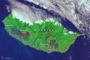
When the Operational Land Imager (OLI) on the Landsat 8 satellite captured this image of Madeira on Aug. 11, 2016, a large fire on the western side of the island was still burning. (Credit: NASA Earth Observatory image by Joshua Stevens, using Landsat data from the U.S. Geological Survey)
When the Operational Land Imager (OLI) on the Landsat 8 satellite captured this image of Madeira on Aug. 11, 2016, a large fire on the western side of the island was still burning. (Credit: NASA Earth Observatory image by Joshua Stevens, using Landsat data from the U.S. Geological Survey)
