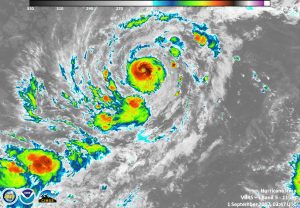
On Sept. 1, 2017, the VIIRS instrument aboard NASA-NOAA's Suomi NPP satellite captured a night-time infrared image of Hurricane Irma in the Atlantic Ocean that showed powerful thunderstorms around the eye. (Credit: NASA/NOAA/UWM-CIMSS, William Straka III)
NASA-NOAA's Suomi NPP Satellite provided a night-time and infrared look at Hurricane Irma, revealing the power under the clouds. NASA's GPM also provided a look at the rainfall being generated by the storm.
Infrared data from the VIIRS instrument aboard showed powerful thunderstorms around the eye, where cloud-top temperatures were as cold as 190 Kelvin. The colder the cloud tops, the higher they are in the troposphere, and the more powerful the storms. NASA research has shown that storms with cloud-top temperatures that cold have the potential to generate heavy rainfall.

