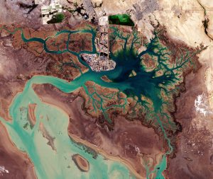
Large geometric structures along the top of this ESA satellite image appear to be evaporation ponds for extracting naturally occurring minerals from the ground. (Credit: contains modified Copernicus Sentinel data (2017), processed by ESA)
The European Space Agency (ESA) Copernicus Sentinel-2A satellite captured this image of Iran's Musa Bay on the northern end of the Persian Gulf on Jan. 13, 2017. The image's center shows the port city of Bandar Imam Khomeini, situated at the terminus of the Trans-Iranian Railway: a route that links the Persian Gulf with Iran's capital, Tehran.
The dark area to the right of the port is Musa Bay, a shallow estuary. The image's left side is dominated by the marshes and mudflats of the Shadegan wildlife refuge: the largest wetland in Iran, which plays a significant role in the area's natural ecology.
The area provides a wintering habitat for a wide variety of migratory birds and is the most important site in the world for a rare species of aquatic bird: the marbled duck. The northern part of the wetland is a vital freshwater habitat for many endangered species. This area is considered a wetland of international importance by the Ramsar Convention, an intergovernmental treaty for the sustainable use of wetlands.
