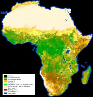
 A 20-meter-resolution land-cover classification map of Africa was created using 180,000 Copernicus Sentinel-2A images captured between December 2015 and December 2016.
Land-cover mapping breaks down the different types of material on Earth's surface, which is important for understanding changes in land use, modelling climate change extent and impacts, conserving biodiversity, and managing natural resources.
(Photo Credit: Contains modified Copernicus Sentinel data (2015-2016), processed by Land Cover CCI, ESA)
