Geospatial Data and Model Discovery
In the age of big data, the volume of geospatial information available through disparate sources can be overwhelming. Even the most sophisticated users often struggle to discover the right data and models to make decisions and solve problems. But finding the right data and models is just part of the issue.
As the pace of doing business accelerates, the ability to quickly access advanced geospatial analytics is critical. Extra time spent gathering data is time wasted. The real challenge is finding the right data and models quickly to enable agile decision making.
Finding the Best Geospatial Data and Models
The Intelligent Data Exploration and Analytic System (IDEAS) enables agile decision making through an intuitive, Web-based platform. IDEAS provides a single interface into federated, stove-piped data repositories to allow on-demand access to a vast array of satellite and aerial imagery. But IDEAS does more than simply compile the data”it connects users to models that let them process and analyze their data to create powerful visualization products and decision-support tools.
A wide spectrum of users can find value in IDEAS”users who want fast and simple access to all types of geospatial remote sensing data for commercial applications, applied science and societal benefit. Drought management, insurance, land and resource management, petroleum exploration and disaster response are just a few examples where IDEAS delivers value to the decision process.
IDEAS also enhances collaboration among the geographic information system user community. As people continue to upload new models, discover other models and access newly developed products, the entire community benefits from a more robust solution environment.
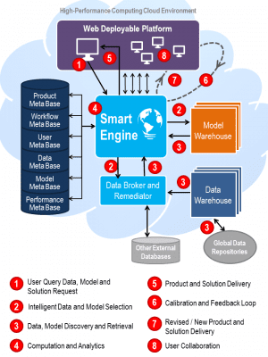
An integrated Web interface, smart engine and high-performance computing backbone allow IDEAS to rapidly deploy data, models and analytic capabilities.
The browser-based interface provides an intuitive user experience for discovery of and access to geospatial data and models. The smart engine integrates open source and commercial technology to apply innovative methods, such as learned workflows and Model as a Service functionality, to solution generation, user feedback, community collaboration and product delivery. Finally, the high-performance computing backbone enables big data in motion analytics.
About The SI Organization, Inc.
The SI Organization, Inc. (the SI) delivers integrated geospatial data along with innovative products and mission solutions to solve global problems. The SI has a 40-year heritage delivering innovative technology and integrated solutions and employs more than 2,100 people around the world.
For more information, visit www.thesiorg.com/ideas.


