Progressive organizations need a unified approach to manage geospatial data.
By Mladen Stojic, vice president”Geospatial, Intergraph (www.intergraph.com), Norcross, Ga.

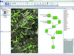
Intergraph Geospatial 2013 connects all geospatial genres, integrating photogrammetry, remote sensing and GIS into a streamlined system. For example, the next-generation ERDAS IMAGINE Spatial Modeler allows users to generate on-the-fly results of their geospatial analysis.
Today's progressive organizations rely on comprehensive geospatial data to drive smarter decisions. The right kind of locational and situational awareness can enhance efficiencies as well as drive business efforts that enhance the bottom line.

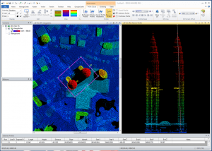
ERDAS IMAGINE now features a fully integrated 3-D point cloud viewer, allowing users to analyze point clouds in detail with 3-D and multiview cross-sections.
In other words, we're headed into an era where geospatial data are reaching near ubiquity in their ability to drive organizational success. On one level, this is an exciting time for users and providers of geospatial software and solutions. But with any type of revolution, there always are hurdles to overcome.
With a slow-growth economy and proposed budget cuts, all organizations”from federal agencies to utilities”simply need to do more with less. For the defense arena, this means always achieving mission goals with less investment in the right technologies. For large commercial organizations, this means using the most cost-effective solutions that still provide quality geospatial data management.
Employing a Unified Approach
To achieve the highest levels of efficiency within certain budget parameters, today's organizations require one unified offering that incorporates every type of geospatial solution. From data capture and fusion in an integrated environment to on-demand geoprocessing and map production, unified solutions can deliver real-time intelligence to users, whether on a desktop or mobile device.
In the past, many organizations purchased several different geospatial products from multiple vendors. Each vendor provided its own interface, proprietary formats, multiple license managers, different customer support and conflicting maintenance contracts. Such inefficiency resulted in broken workflows, late and incomplete projects, higher training costs, more money spent overall and a disconnected organization operating in silos.
In addition, investing in these disparate technologies often went unchecked in many organizations, so different groups purchased overlapping products. As a result, data silos emerged, which increased spending costs while introducing unnecessary complexity. The end result was more money spent without increased efficiency, along with frequent unnecessary political battles within an organization.
When considering the legacy use of many vendor solutions, organizations are limited in their ability to model the world, which also increases the costs needed to build systems that extend the use of geographic information to those outside the niche geographic information system (GIS) domain. Today's organizations need to get the power of geography into the hands of people who need to make smarter decisions.
Thankfully, now organizations can tap into industry providers that offer a united portfolio, which contains the power and the depth required to do all of the tasks needed to make users more productive. In addition, this unified approach provides streamlined workflows across disciplines, training and support from a single company and licensing from one vendor. In other words, now organizations can fully leverage geospatial data in ways never imagined.
Synthesizing Core Geospatial Technologies
The essence of this unified approach is the ability to synthesize core geospatial technologies to offer one integrated dynamic modeling environment for creating spatial models. For producing information about Earth and its human, physical and social geography, these models can achieve an exponential effectiveness with fully combined solutions. It's also important to note that, with the connected workflows between the desktop and the server, new unified solutions can deliver on-demand information products from the desktop, through the server and to Web-connected users in the field.

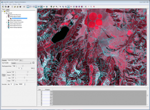
The new segmentation algorithm in IMAGINE Ob jective provides users with simple options to create the most representative object for a project. A user can set the mean pixel to segment ratio, and then provide the relative weights of color, shape, size and texture based on the input image and the required output.
Such integrated solutions are fusing the genres of photogrammetry and remote sensing, which includes providing consistent, streamlined workflows for project-based photogrammetry. Many tools and features now can be accessed within the same ribbon interface used by remote sensing analysis and geospatial modeling software. In addition, navigating between applications and graphic user interfaces no longer will be a requirement to ensure photogrammetric and remote sensing functionality, which now can be fully utilized throughout a project. The result is that organizations can derive the utmost value from their imagery and geospatial data investments.
Installing, configuring and deploying production-ready enterprise systems can be time consuming, tedious and complicated. In the past, the fragmented and disconnected network of open-source tools and applications have introduced complicated and inconsistent workflows, making the installation and configuration of geospatial enterprise systems all the more difficult. A solution to this problem is a single enterprise administration console and one common and consistent Web client framework.
A new harmonized approach with tight server integration enables organizations to easily install, configure and deploy systems. Another way to bring technologies together is leveraging a single unified thin -client framework for building geoportals and Web applications. A thin-client framework allows users to simply showcase the power of geography in a context- and information-rich environment.
Better Understanding Our Ever-Changing World
Human, social and physical geography are changing at an incredible pace. Whether it's through man-made or naturally occurring changes, the world will continue to be transformed before our eyes.
In addition, we're facing the highest levels of uncertainties in the form of natural and man-made disasters, requiring organizations to be nimble, proactive and effective. In cases with lives on the line, there's no room for decision making to be slowed down by organizational and technology silos.
In parallel, the world's expectations for how, where and when information is delivered also have changed. Users expect information to be delivered on demand in a context- and application-relevant form to the field, in the office and online for others to use. Because working with geospatial data can be complex, bringing on-demand solutions to users never has been easy. Such difficulties can be seen in the defense sector, which requires real-time actionable data for warfighters, as well as with larger utilities that need to have full situational awareness of all their field assets.
To meet these growing expectations, dynamic geospatial systems are required to fuse multisource content with powerful geoprocessing. Once united, organizations can deliver context relevant smart maps to users across departmental silos and into the world. This is the future of geospatial technology.

