Five university students working with project managers in Mexico, Colombia and France leverage Planet Action resources to achieve winning results.
By Mary Jo Wagner, freelance writer, editor and media consultant, Vancouver, British Columbia, Canada.
Energized by the launch of the International Polar Year in 2007, two companies came together the same year to
initiate their own commitment to the planet. Planet Action (PA) was co-founded by satellite data provider Spot
Image, now Astrium GEO-Information Services (www.astrium-geo.com), and geographic information system
(GIS) provider Esri (www.esri.com) to provide geospatial technology and expertise to organizations working on
climate change causes, impacts and solutions.
To understand the significantly challenging mission of Planet Action's projects, consider a small sampling of
typical land issues facing our planet.
¢ Mexico loses on average 350,000 hectares of forested land every year, an area about the size of Rhode Island.
¢ Colombia loses nearly 200,000 hectares of forests every year”though the true figure may be higher, because
an estimated 100,000 hectares of native forest are illegally cleared annually.
¢ France has a mountainous region in the Pyrenees with an uncertain environmental future. The abrupt abandonment of this formerly human-dominated land in the 20th century, coupled with natural afforestation, has produced an organically grown land-use conundrum”how to understand the impacts of this severe land-cover change and create a balanced ecosystem that supports both biodiversity and the return of human interest in the land.
These three examples are just a razor-thin slice of the environmental issues layering the globe. However, they
represent three successful beginnings on the elusive road to environmental sustainability, the ultimate goal for the hundreds of projects Planet Action supports. And on a personal note for five students at the University of Vermont, these three projects seeded a unique work-study class and helped launch five geospatial careers.
A Work-Study Debut
Planet Action has supported more than 600 nonprofit projects worldwide in various domains such as biodiversity, forestry and water resources. Through the donations of satellite images, GIS solutions and image processing systems by program partners, Planet Action supports both small, local agencies such as nongovernmental organizations, universities and research centers as well as large agencies such as the United Nations Educational, Scientific and Cultural Organization, the World Wildlife Fund, the Green Belt Movement and Imazon.
Planet Action donated more than 1,000 satellite images alone in 2011, and program partner Trimble
(www.trimble.com) donated its eCognition image analysis software licenses to aid users in their image processing tasks”to date, more than 100 eCognition Developer licenses have been donated to more than 50 projects in 43 countries.

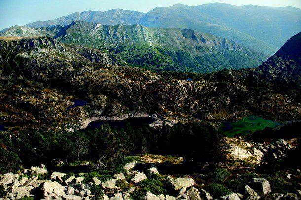
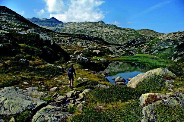
The Ariège region of southwestern France is one of hundreds of areas being studied by Planet Action researchers.

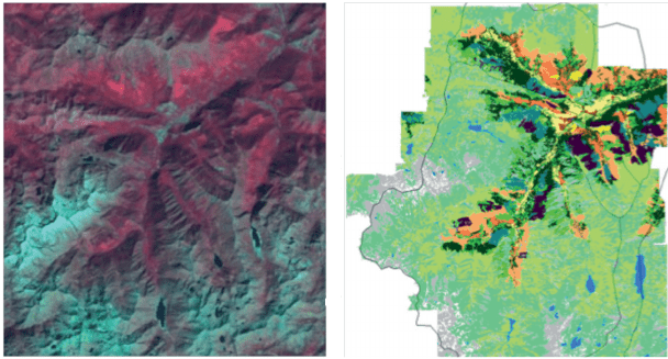
Producing land-cover maps for mountainous areas such as the Pyrenees (above) is difficult for traditional land-classification technologies. Using satellite imagery (left) and object-based image analysis software, researchers were able to quickly distinguish 11 class types and map them (right).
Starting with a small roster of 13 projects, by 2010 Planet Action was involved in 500 and since has added 150
more. Three of the 2010 projects were those from Mexico, Colombia and France, all of which required satellite
imagery to classify and map land cover, but for notably different environment types”mangroves, dense forests and an alpine ecosystem. Each environment presents unique classification challenges, requiring an image-analysis system that could delve beyond traditional pixel colors and recognize contextual elements to clearly distinguish different vegetative types. The respective project managers wanted to produce data layers with Trimble's eCognition, object-based image analysis (OBIA) software, but they didn't have the in-house resources to take on the task.
Enter the University of Vermont's Spatial Analysis Laboratory (SAL). SAL's personnel use eCognition
extensively for their varied work, including biodiversity analysis, land-cover mapping and urban tree-canopy
assessments. Their work has been so successful, SAL's Director Jarlath O'Neil-Dunne”who has been an
eCognition user since 2002”was able to establish the university's eCognition Center of Excellence in 2009 (now Trimble Imaging Innovation Program), which has helped to further augment SAL's prestige and revenue.
With such a prominent profile, it didn't take long for Trimble to connect O'Neil-Dunne with the three Planet
Action projects”a connection that came at about the same time a group of five students involved with the lab were keenly interested in becoming more proficient in OBIA.
This was an ideal need-need pairing, says O'Neil-Dunne. Not only were the projects particularly well suited
for object-based image analysis, they would enable these students and the project managers to learn the
capabilities of the software through hands-on, real-world projects with deadlines, specific deliverables and end users greatly invested in the outcomes.
And with that, a work-study class was born.
A for Effort
Starting in January 2011, O'Neil-Dunne assigned the class of five their respective projects”two students for
Mexico, two for Colombia and one for France. After a two-week tutorial on the eCognition software, the students had four months to acquire the satellite imagery and supplemental data, process them and deliver the required maps to the end users. Although O'Neil-Dunne recognized this class would be a unique opportunity for the students, he also knew it would come with risks.
Being able to apply their knowledge and skills to real-world projects would be an incredibly effective way to
learn, but it would come against the backdrop of a tight deadline, with project managers they've never met and for whom English is not their native tongue, in three different time zones, he explains. It was a risky proposition, but it all worked out very well.
To help ease communication and support technology knowledge transfer between the Planet Action project
managers and the University of Vermont students, Trimble offered the use of its dedicated online platform,
eCognition Community, where all project participants could discuss issues, exchange ideas and blog results.
The students were provided Spot images and supplemental data such as digital elevation models (DEMs).
Using eCognition, they incorporated the imagery into the software and created customized rule sets, a workflow of if-then scenarios to automatically classify specific vegetative types and environs, which then were mapped according to user specifications.
For Mexico, they produced hard-copy thematic maps of the Sierra de la Cruces region, a 200,000-hectare
forested area west of Mexico City. The maps definitively show urban areas; water resources; grasslands; and
specific tree types, including pine, fir and oak. The land-cover classification is serving as the basis for further
ecological field data being collected and the ongoing analysis of landscape patterns to help develop strategies to curb the area's rampant deforestation.
In Colombia, the objective was to map the present extent of the mangrove forest and other wetlands and
flooded forest wetlands within the Darien region, which lies near the border with Panama and has been heavily
impacted by logging, mining, and clearing for agriculture and cattle ranching. Based on the OBIA processing, the students were able to deliver detailed maps of the mangrove forest and associated wetlands. Now the maps aid the project team in developing community-driven proposals to halt the forest's deforestation and degradation. In addition to the detailed classification maps, O'Neil-Dunne also required the students to provide the processing knowledge used to generate the data products”the customized eCognition rule sets.
The ability to clearly distinguish a wetland, for example, which is quite hard for traditional pixel-based image
processing solutions to adequately do, and to automatically map it is a powerful tool for these projects, says
O'Neil-Dunne. Even more valuable is to have the ˜process tree,' the step-by-step procedure of how the software was instructed to identify vegetative types like mangroves, for example. That provides the project managers with a master knowledge base for today and for the future.
A Right-Brain Approach
For the French project, that future has arrived. Indeed, early classification work on the Pyrenees project
showed Thomas Houet, the project manager and associate researcher at the French National Research Center
(CNRS), that students would be able to meet their mapping needs and pursue a different exploratory path that led to a successful grant to continue the project.
When University of Vermont student Daniel Koopman was assigned the Pyrenees project, his primary objective was to produce a land-cover classification map of a 245-square-kilometer area in the Vicdessos valley in the Ariège region of southwestern France. Designated a long-term Human-Nature Observation site and supported by the Institute of Ecology and Environment of the CNRS (InEE“CNRS) and the LABEX DRIIHM, this particular area of interest in the Midi-Pyrenees region has suffered significant land-use changes over centuries of upheavals.
For 6,000 years the region was dominated by the agropastoral industry, coupled with decades of industrial
activity. Then, in the late 19th and early 20th century, rapid depopulation”largely due to two world wars and the economic and social attractiveness of urban areas”led to the end of transhumance, i.e., leading livestock to higher regions for summer months, and shrunk the size of cultivatable land. This chain of events has allowed the region to organically transition back to a natural ecosystem, leaving it with an uncertain role for modern-day land-use possibilities. This uncertainty has been of particular concern for InEE-CNRS, which has been striving to understand these land-cover changes and their impacts during the last 50 years to help authorities better shape the region's environmental planning and development.
Although the region's historical changes are well studied, Houet wanted to capitalize on technological
advancements to more efficiently and effectively map changes during the last few years. But first, he needed to
have Koopman”who is experienced in classifying alpine ecosystems”create an accurate, current land-
classification map for the area of interest, which comprises a lower valley, an intermediary zone favored by
agricultural activity and a high-mountain zone dominated by dramatic changes in vegetation.
Producing land-cover maps for mountainous areas such as the Midi-Pyrenees has been problematic for
traditional land-classification technologies because slopes, sun and satellite angles strongly affect spectral
measurements, says Houet. The advanced OBIA technology now enables us to overcome these unique
challenges and map these regions with accuracy we couldn't achieve before.
Koopman was given two 5-meter-resolution Spot scenes acquired in 2010 and a 30-meter-resolution DEM
produced from data collected by the Advanced Spaceborne Thermal Emission and Reflection Radiometer (ASTER) instrument on NASA's Terra satellite. He also had ancillary datasets, including a vector layer, a buildings layer and a water layer, to help with the classification”all of which, coupled with the satellite data, were integrated into eCognition to build the customized rule set. Using his alpine-studies experience, Koopman first defined the landscape characteristics of each zone”typical tree cover, slope angles, proximities to urban areas”and then began writing rules to train the software to mimic the process the human brain uses to distinguish specific environmental features.
Teaching the software to perform a sophisticated process that the brain does superiorly, in microseconds, is one of the main challenges of OBIA, but it is also what makes it special, explains Koopman. The ˜left brain' of the software is typical of traditional image-processing tools in that it matches the spectral properties of a pixel with its typical land class, but it also has a ˜right brain,' which allows you to go beyond spectral properties and more into contextual and relational areas.
For example, you can not only classify a tree, you can specify the exact type of tree based on its geographic
position““certain tree types only grow at certain elevations. The ability to consider an object's surroundings gives you the power to create much more accurate classifications““datasets that I can create in one single software package, using a replicable methodology, in minutes.
In four months, Koopman had developed the needed process tree to distinguish 11 class types, including
valley, intermediate and mixed alpine grasslands, snow, coniferous forest, deciduous trees and wetlands, and map them. Although the rule set took months to build, it only took 10 minutes to run the workflow and create the classification map. Koopman delivered the map and associated eCognition rule set”the classification gold, says Koopman”to Houet in May 2011.
Based on the map detail and his own eCognition experience gleaned from collaborating on the project, Houet
secured funding from CNRS to continue to collaborate with Koopman on the project, but with a slightly more
challenging objective. In September 2012, Koopman travelled to France to help conduct fieldwork to determine if it would be possible to apply eCognition to the existing land-cover map and deduce land-use change.
Land-use change adds more complexity, because it requires you to make sophisticated assumptions and add
human components to the analysis, says Koopman. The goal is to see if we can develop a flexible enough rule set to create land-use maps independent of time”a rule set that can be applied to historical remote sensing data and future datasets acquired.
A Work-Study Sequel?
Though a risky prospect at the outset, O'Neil-Dunne's debut Planet Action work-study class was a success. Not
only did his five students meet each project's requirements in just one semester, he also took pride in knowing that their eCognition class experience helped them secure full-time jobs in the geospatial industry.
Koopman was hired by Geostellar, a solar energy company, in January 2012, and uses eCognition software
daily in his work. And, according to O'Neil-Dunne, the other four students all acquired jobs in the geospatial
industry.
I think these projects were big selling points on their resumes, says O'Neil-Dunne. With the students' careers well under way, O'Neil-Dunne hopes to play matchmaker again with the right Planet Action projects and the right group of students. With Planet Action's unabated mission, chances are high he will succeed.


