Geospatial innovations are creating a new dynamic geospatial ecosystem that fuses geography with Web, mobile, tablet and crowd-sourced environments.
Finally, the geospatial sector is on the leading edge of providing a modern user experience that's relevant to the world.
By Mladen Stojic, vice president,Geospatial, Intergraph (www.intergraph.com), Norcross, Ga.
A new, younger generation of users is entering the geospatial workforce, bringing change to both mature and emerging markets. Molded by the explosion of elegant and highly intuitive Web, mobile and tablet applications, this new generation has different expectations for how software applications should work and operate. When presented with geospatial applications designed for a niche user, this new generation often is perplexed or frustrated with the disconnect between modern user expectations and antiquated applications.

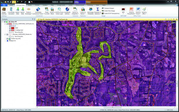
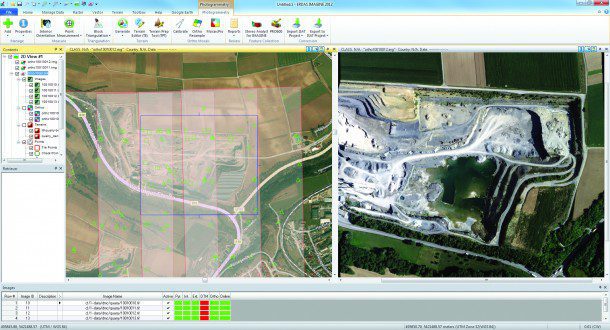
The 2013 release of ERDAS IMAGINE provides users with greater raster and vector integration to optimize workflow performance.
As a result of such expectations, new solutions entering the marketplace are embracing a fresh, modern approach. Simple solutions are taking on the highest form of elegance while redefining how geospatial workflows can be streamlined to improve productivity, lower training costs and increase utilization. The end result is a simple solution that lets users derive more information more quickly from multisource content.
We're also seeing a new market need for smart maps that incorporate real-time information to provide a multidimensional view of the world. These integrated solutions provide a mechanism for making smarter decisions. High-fidelity content is fused together within a smart map, and information contained within the map is application and context specific to meet the needs of a customer's unique workflow. This information also is updated as the world changes and is available in mobile formats.
Remembering the Past
To push geospatial solutions into the hands of next-generation users, it's important to understand the path we've taken to where we are today. From the early days of cartography, which was commissioned by kings and created by a few, to 4-D mobile mapping, we've seen an evolution in mapping that has driven us to where we are today.

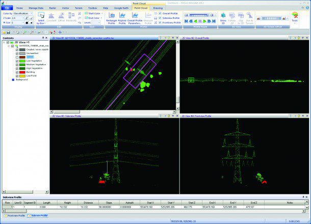
A classified LiDAR dataset of a power line corridor with the ground class turned off can be used to measure encroaching vegetation. Shown here are the planimetric view and three profile views.
For example, surveying in the 1700s grew into photogrammetry in the 1900s. From there, we had the rise of geographic information system (GIS), computer-aided design (CAD) and paper maps to remote sensing, which eventually moved into the areas of Global Positioning System (GPS), Web mapping, light detection and ranging (LiDAR) mapping and mapping for the consumer market.
This linear evolution has brought us to a unique crossroads. The combination of modern users, modern geospatial education systems and modern technologies has created a perfect storm that requires us to deliver solutions that exceed market expectations.
Next-generation users are growing up on mobile devices and simple-to-use applications. The geospatial sector finally is at a point where we're moving away from cumbersome systems that only appealed to the few to relevant apps relevant to the world.
New solutions from the industry are bringing modern interfaces and an approach that will allow geospatial solutions to transcend organizational silos. Geospatial technologies always have served as the backbone for all organizational decision making, whether it's for a defense agency or a forestry organization. The key is making these solutions easy for everyone to use by matching modern user expectations, which are elegant as well as mobile- and cloud-based, with today's product design and development efforts.
Bringing a Modern Approach to Life
Advocating for innovation in the geospatial sector and actually bringing the right solutions to the marketplace are two different approaches”one is idea based, while the other is entrepreneurial. Leaders in our unique niche understand there's a vital need to develop innovations that meet current user demands, though bringing them to life can be a different story.
Fortunately, there are now instances of this modern approach in the market. For example, new ribbon interfaces are easier to use and organize the experience based on the tools needed and the workflows users want to create.
Now users can enjoy clean and streamlined interactive spatial analysis and modeling workflows with new geographical interfaces that incorporate user-defined workflows, key vector and grid operators, Python scripting and real-time previews of results. As many larger enterprises traditionally embrace Microsoft-based operating systems, newer solutions now offer Windows 8 support.
In addition, new industry innovations provide a complete set of tools that work directly with point cloud data derived from LiDAR technology. This includes the ability to simultaneously view point clouds in 2-D, 3-D and cross section. In addition, these new LiDAR toolsets provide colorizing and filtering options for visualization and interpretation, allowing users to better leverage this type of data.
Many Web service offerings now meet all Open Geospatial Consortium (OGC) and Infrastructure for Spatial Information in the European Community (INSPIRE) specifications, allowing organizations to use open standards for enhanced flexibility. In addition, new solutions allow users to enjoy business-specific workflows that use geospatial capabilities and intuitive Web editing, which can be accessed and used across an organization to get information into the hands of those who need it.
Lessons Learned from the Music Industry
In addition to changes that modernize existing applications, several new approaches are being realized. Forward-thinking industry providers are branching out beyond traditional product design methods to meet the unique needs of today's users. Ease of use is now the driving strategy for product development.
A core component of this approach is mobility. For 2013, Gartner is estimating that more people will access the Web via mobile devices than by using traditional PCs. This in itself is a strong case for focusing on the new geospatial mobile arena.
In addition, more cloud-based solutions are luring individuals to access and use geospatial data. This approach is similar to what has been successful for the music industry. Just as songs now are available through cloud-based streaming services, the geospatial sector is starting to provide data and applications with a similar model. The key to making geospatial solutions more appealing to a broader audience is to make them as easy to use”and alluring”as an application
like Garage Band. Now the industry must consider creative and innovative approaches that bring smart maps to life.
The explosion of consumer technologies has allowed any amateur musician to record and distribute music over the Web. In addition, these musicians can use software programs that allow them to fuse musical genres to blend styles, beats, themes and harmonies to make music relevant, global and appealing to a new generation
Just as today's music technologies are engaging a larger audience, new geospatial systems are breaking down barriers, including departmental walls within organizations, previously defined geospatial genres and stovepipe applications. Previously, these areas of separation prevented the widespread use of geographic data and information, hindering use for those outside a defined group.

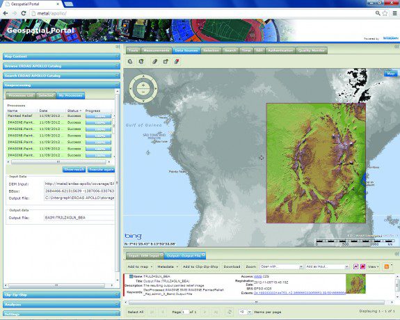
In conjunction with Intergraph's Geospatial Portal, ERDAS APOLLO offers on-the-fly geoprocessing that enables users to execute robust and complex spatial models from a Web client.
Combining best-of-breed technologies, geospatial innovations are creating a new dynamic geospatial ecosystem that fuses geography with Web, mobile, tablet and crowd-sourced environments. Ultimately, such integration will allow anyone to discover the power of geography, fusing all geospatial genres and data to create real-world solutions on demand.
Smart organizations need to be able to fuse together all the different geospatial genres quickly and easily for making informed, timely decisions. Whereas musicians use technology to make innovative soundscapes, this analogy can be brought to the enterprise geospatial sector through smart maps.


