User Expectations Drive New Applications

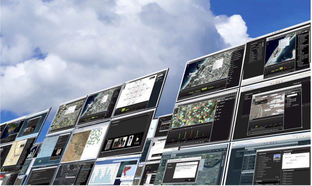
Cloud computing and mobile application solutions are being used to support GIS users through a growing number of new technologies. Credit:Overwatch Systems
By James S. Blundell, vice president, Geospatial Products and Solutions, Overwatch Systems (www.overwatch.com), Sterling, Va.
Combining the strengths of best-in-breed geographic information system (GIS) and image processing technologies is a key element of successful geospatial analysis. Today's complex array of Earth imagery choices”electro-optical (EO), synthetic aperture radar (SAR), light detection and ranging (LiDAR) and full-motion video (FMV) imagery”requires a sophisticated capability to deliver the right information into a GIS application. Success also requires users to account for the complexities of image metadata, sensor models and other collection parameters during the data processing and exploitation cycle.

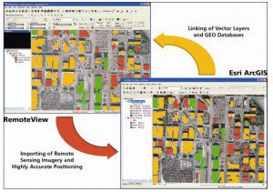
Overwatch's RVConnect extension links the remote sensing capabilities of RemoteView software with the vector GIS capabilities of Esri's ArcGIS.
GIS is a core consumer information technology that supports traditional cartographic requirements and new vertical markets in the insurance, public health, public safety, banking and business arenas. These and other markets are discovering the efficacy of location-based analytics and visualization. Remote sensing adds value to this mix by enabling near-persistent surveillance of key geographic areas, identifying anomalies through spectral processing and accurately modeling terrain.
The Deepwater Horizon oil rig explosion, and subsequent oil spill crisis in the Gulf of Mexico, is a great example of how this technology can meet immediate needs (see image page 26). SAR images and other remote sensing data were streamed to first responders, enabling more effective planning and deployment of resources across a vast area of open water and shoreline.
As geospatial applications, such as Google Earth, become more ingrained in daily decision making, the vendor community is raising the bar to provide users with more sophisticated visualization experiences and analytic content, such as incorporating 3-D or streaming video content into mobile mapping applications. Delivering this type of information into a GIS requires new approaches to managing remote sensing data in terms of processing and software integration.
The standard solution is to create a GIS plug-in, allowing desktop users to render nonmap-projected imagery content, visualize stereo imagery or filter large LiDAR point-cloud files. New technology concepts involve cloud computing and simple applications that take advantage of consumers being connected to the Internet via cell phone, automobile (mobile Wi-Fi) and tablet computers (see Covering All the Bases at right).
An intriguing question during this transition to cloud computing is how much geopositional accuracy will suffer at the expense of visualization of content. A picture may be worth a thousand words, but imagery in a GIS application is expected to support concepts such as map projection, coordinate systems, error estimates, etc. On the other hand, many of the Deepwater Horizon oil spill images were collected by airborne platforms with varying levels of processing applied, affecting their usefulness and accuracy for some applications. However, these inaccuracies weren't an issue for the general public and local businesses”they simply wanted to view the status of the spill and judge whether it was moving closer to populated coastal areas and pristine beaches.
Ultimately, accuracy requirements are up to the end user's needs and application requirements. National Technical Means (NTM) imagery isn't required to support land-cover mapping, and Google Earth imagery is good enough to support the planning of a family vacation. Successful vendors connecting GIS and remote sensing data align themselves with consumers and learn to deliver good enough visualization and analytics based on the application, cost and perceived value.
Consumer expectations will, to a large extent, parallel their experiences on the Web, where content is free, on demand and hassle free. Most consumers want answers without the knowledge and training normally required to view complex data. This expectation is driving new concepts in delivering information from remote sensing data into GIS applications, especially in areas such as visualization, analytics and change detection.

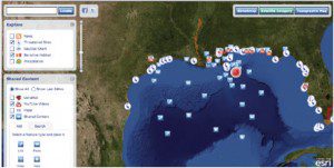
In response to the Deepwater Horizon disaster, Esri developed an oil spill map application that allows users to overlay imagery data with links to online photos, Web sites and YouTube videos.
The concept of detecting and visualizing change is especially intriguing from a remote sensing and GIS perspective. Although many areas of the developing world still aren't adequately mapped, the baseline for existing GIS data in the United States and Western Europe is such that mapping change is both desired and possible. For example, one of the fallouts from the real estate bubble may be an application that consumers can use to visualize change from a foreclosure perspective, with queries such as, Show me all home-ownership changes and land development over a 10-year period so I can assess the stability of an area before I buy a home there. This type of simple application requires analytics (processing home ownership tabular data) and visualization (research and negation of multiple images collected over a specific geographic area).
The concept of the GIS plug-in will continue to evolve, allowing users to create and consume all types of geospatial content. For the remote sensing purist, traditional concepts of GIS accuracy always will be central to mapping and imagery analysis tasks. Average consumers, however, appear open to good enough geospatial content as long as it easily and effectively meets their needs.
Covering All the Bases
The geospatial industry is at a crossroads between traditional software plug-ins for desktop GIS users and cloud computing that is widely accessible and available. A handful of companies seeks to support both approaches, as well as the new generation of wireless consumers. For example, Overwatch's image analysis software RemoteView and ELT, when combined with Esri's ArcGIS, opens a new world of possibilities for GIS analysts looking to explore the full potential of remote sensing for mapping and advanced geospatial analysis.
Overwatch's RVConnect software lets users connect RemoteView and ELT with ArcGIS for 3-D visualization, image analysis and product generation using a wide array of data such as LiDAR points, vector shape files and Earth imagery. ArcGIS plug-in applications include Feature Analyst and LIDAR Analyst to extract 2-D and 3-D feature data from imagery and LiDAR directly into GIS databases. This combination of remote sensing and GIS software gives analysts the benefits of on-the-fly image processing and integrated feature-extraction workflows.
Cloud computing and mobile application solutions also are being used to support GIS users through technology such as Overwatch's Cloudwave and SoldierEyes. For example, mobile users can consume remote sensing data to determine where a helicopter should land in a two-kilometer radius from a given location, or Web services on a network can perform image-to-ground space conversion.
Credit:Overwatch Systems

