As more users incorporate oblique imagery solutions into their workflows, clearly defined industry standards are needed to ensure consistent, accurate results.
By Sanchit Agarwal, director of mapping operations, The Sanborn Map Company (www.sanborn.com), Colorado Springs, Colo.
Although oblique imaging products have been part of the mainstream mapping industry for more than a decade, none of the accredited mapping societies have provided standards that define accuracy requirements for oblique imagery. This is mainly due to the layers of complexity posed by camera technology, georeferencing techniques and online viewers.

Oblique imagery allows users to see multiple aerial views of any location, such as this area of downtown Dallas. If the oblique data are tied to mapping-level accuracies, the data can be used to generate a variety of value-added products.
Little Accuracy, Limited Value
The science of measuring with photographs is called photogrammetry. Traditionally, remote sensing professionals extracted 3-D measurements by meshing stereo images with an accurate geometric model (aerial triangulation output) in a 3-D viewing environment. This capability requires specialized software and hardware that can't be deployed easily on a Web-based platform. However, in oblique projects, there has been a push to defy this basic photogrammetric principle and provide measurement capabilities to end users with 2-D (non-orthorectified) images through a simple Web-browser-based platform.
In most cases, oblique imagery is disseminated and consumed with an image viewer”mostly Web- or Esri plug-in-based”with tools that let users explore all five views of a selected location and make basic measurements (length/area/height). Some advanced viewers have added functionalities such as the ability to measure slopes and allow for address-based search options. Additionally, some viewers offer the ability to overlay/access geographic information system (GIS) layers and improve measurement accuracy and reliability by creating mimicked 3-D environments from predefined digital elevation models (DEMs) loaded into the viewer.
To provide measuring capabilities using the 2-D images and flat environments offered by Web browsers, vendors developed creative ways to measure, but most of the techniques were implemented at the mercy of sacrificing measurement accuracy and reliability. Although such techniques let users explore a particular area of interest, they're loosely coupled with traditional photogrammetry principles and aren't very accurate.
But as users become more advanced, they demand more than easy access to pretty pictures to justify the cost of oblique projects. Users want to know the answers to some basic questions. For example, is there a way to improve measurements in an oblique viewer? Can orthorectified imagery be created using the nadir views of the oblique flight? Is there a way to generate digital surface models (DSMs)/digital terrain models (DTMs) from oblique data? Can such data be used to compile vectors/features? More importantly, can the information extracted from oblique data be used to generate 3-D models and products?
Traditionally, most oblique imagery solutions can be summed up as pretty pictures of facades of a building from five directions”good for viewing, but such views don't always offer or guarantee any level of accuracy. Now, with the advent of new technology, oblique imagery products and solutions are available that are generated using photogrammetrically controlled/embedded processes that can meet mapping-level accuracies. If the oblique data are tied to mapping-level accuracies, the imagery's value takes a quantum leap, and the data can be used to generate a variety of value-added products such as orthophotographs, DSMs, DTMs, contours, 3-D buildings and city models.
.")
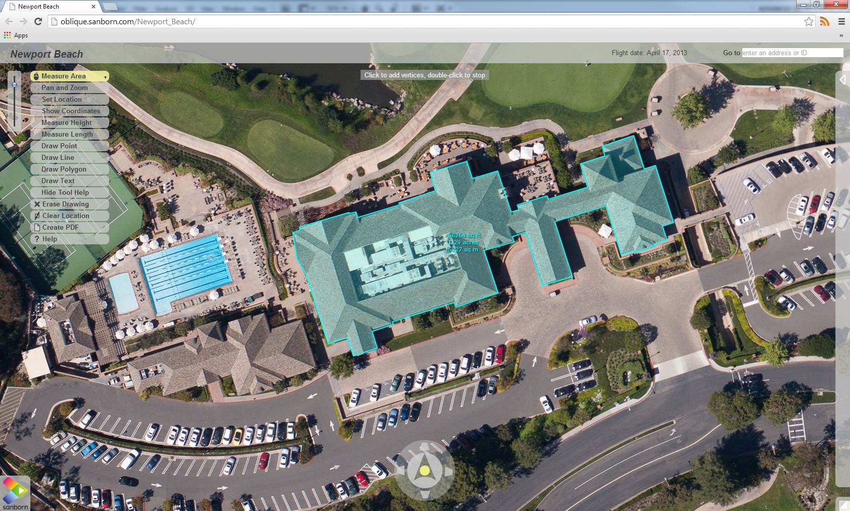
Adhering to rigorous quality standards for oblique imagery acquisition and processing allows the imagery to be used to analyze all sides of a structure or ground feature, including area and height measurements (top and bottom, respectively).
Ensuring Oblique Accuracy
There are two ways in which the accuracy of an oblique project can and should be required, evaluated and reported:
Aerial Triangulation Accuracy Report
Report aerial-triangulation (AT) results to evaluate the accuracy of an oblique imagery dataset. Like traditional photogrammetry, such results should be reported as residuals on tie points, ground control points and independent check points. The AT results give a correct account of the dataset's inherent accuracy.
Such accuracy forms the foundation for any downstream product such as DSMs/DTMs, orthoproducts, planimetric 2-D/3-D feature collection and 3-D models. As with traditional photogrammetry, there should be more stringent guidelines that parallel the American Society for Photogrammetry and Remote Sensing accuracy classes for meeting and reporting an oblique product's AT accuracy.
AT for an oblique imaging system employs techniques similar to conventional AT, including the use of Global Positioning System/inertial measurement unit data, boresight angles, direct georeferencing and tie points/match points/ground control points dictated by a project's accuracy requirements. However, conventional AT software isn't designed to incorporate oblique imagery for tie-point generation or to handle the large amount of data collected with the system. The georeferencing techniques/software used to accurately tie the oblique and nadir images together are based on new concepts such as trajectory modeling, a structure-for-motion approach and advanced computer vision algorithms.
Web Viewer Application Accuracy Report
In most cases the dataset's accuracy at the AT stage doesn't match the dataset's accuracy in the Web-viewer application. The diminished accuracy occurs for various reasons, including:
¢ The algorithm used to implement the measurements using the 2-D images
¢ The terrain variability of the area of interest, e.g., mountainous vs. flat
¢ Diminished resolution and accuracy of the preloaded DEM in the viewer application due to Internet/intranet bandwidth limitations
¢ Lens distortion in the images or incorrectly computed and applied lens distortion in the Web-viewer application
¢ Whether measurements are performed on ground features or above-ground features
Obviously many factors can affect the accuracy of the end-user application, so users should clearly state the functional accuracy requirements of the oblique products in a Web-based viewer environment. The functional accuracy requirements should be less stringent than the AT accuracy requirements and preserve the user experience and intended usability of the measurements. Several criteria can help define the functional user requirements of a Web-based application, including:
¢ When a user clicks on a point of interest, such as a building, the same feature should be visible in other views. The user shouldn't have to pan around to find the same feature in any other view.
¢ The allowable percentage error should be defined in length, area and height measurements.
¢ Absolute accuracy on the ground control points and check points should be separately measured in each view.
¢ The accuracy of the DEM ingested in the viewer application should be defined.
¢ The cohesive coefficient should be available among all the views for ground features.
Making a Case for Standards
Many of these problem would be eliminated if the geospatial industry would create standards to specify, measure and report the accuracy of oblique products. The presence of such standards will provide more power and assurance to the consumers of oblique imagery and products. In addition, standards will create a level playing field for oblique products and service providers, creating a win-win environment for users and developers.
As oblique imagery products become more prevalent, whispers of the need to create scientific and statistical boundaries for oblique products are getting louder”and rightly so. It's about time to unravel the beehive and extract the elixir offered by this wonderful yet oblique concept.
