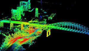
Terrestial LiDAR looks sideways from ground level, enabling it to capture vertical details, such as water levels, that airborne LiDAR can't.
U.S. Geological Survey scientists are employing terrestrial light detection and ranging (LiDAR) technology to map urban flooding caused by Hurricane Isaac. This new capability will enable scientists to collect highly detailed information in select population areas in Louisiana, Mississippi and Alabama where the hurricane had the greatest impact.
The portable instrument allows scientists to quickly generate 3-D maps of buildings, dams, levees and other structures as well as show areas of storm damage. In a four- to five-minute scan, the instrument collects millions of topographic data points in a full 360-degree view to quickly produce accurate topographic information and can map areas up to two-thirds of a mile away.
USGS will use the information gathered from this pilot project to develop 3-D models of streets and structures, including the levels floodwaters reached and current water levels, in the form of an interactive 3-D flood inundation map. The map will help identify where the potential threat of future floodwaters is greatest and determine the extent of wind and flood damages caused by Isaac.

