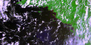
The first raw image from the Proba-V satellite was acquired over France's west coast on May 15, 2013. Less than a cubic meter in volume, the miniature European Space Agency satellite is tasked with mapping land cover and vegetation growth across the entire planet every two days.
The first global vegetation map from the recently launched Proba-V demonstrates the minisatellite is on track to continue a 15-year legacy of global vegetation monitoring from space.
Proba-V is designed to map land cover and vegetation growth across the entire planet every two days. The data can also be used for day-by-day tracking of extreme weather, alerting authorities to crop failures, monitoring inland water resources, and tracing the steady spread of deserts and deforestation.
Slightly larger than a washing machine, the miniature satellite was launched from French Guiana in the early hours of May 7. Just more than a week later, the satellite's Vegetation imager was switched on in time to capture its first image over France's west coast along the Bay of Biscay. While still being commissioned, the satellite continued to acquire images that have been stitched together to provide the mission's first, uncalibrated map of global vegetation, which was unveiled in early July at the Probing Vegetation conference in Antwerp, Belgium.
Image courtesy of the European Space Agency.

