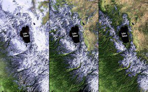
California is experiencing a severe drought. These images show reduced snowfall in the Sierra Nevada Mountains through 2011, 2013 and 2014. (Credit: NASA)
A NASA Big Data system, developed and maintained by Raytheon, is helping scientists forecast the potential impact climate change may have on human health, safety and security issues worldwide.
The NASA Goddard Space Flight Earth science data program is tasked with a monumental mission: use satellites, aircraft and ground sensors to collect a vast amount of information about our planet, and make all of that data”from temperature readings to high-resolution satellite imagery”available to the world.
In 1992, NASA and Raytheon developed the Earth Observing System Data and Information System (EOSDIS) for archiving and sharing exponentially growing amounts of climate information. As storage technology evolved from tapes to data centers, Raytheon migrated existing data to newer systems.
We now have about 9.1 petabytes of data stored at 12 data centers. It's enough data to fill the Library of Congress 900 times, said Tim Ortiz, program manager at Raytheon.
EOSDIS was developed by Raytheon engineers in coordination with data and Earth scientists, Web developers and design experts. Through the years, Raytheon delivered incremental EOSDIS upgrades during regular operations, a practice known as modernization through sustainment. Cutting-edge technologies, including advanced visualization and Web-enabled access, were added with minimal interruption to operations. Raytheon's latest EOSDIS Evolution and Development (EED-2) contract award will allow continued operations, maintenance and sustainment support for the ever-expanding system.
Raytheon's Visible Infrared Imaging Radiometer Suite (VIIRS) instruments on current and planned satellites provide data for advanced weather prediction, covering the globe every 14 hours. In addition to producing high-resolution images of the Earth (like the iconic Blue Marble), VIIRS collects data in 22 different spectral bands, providing critical information used by industries as diverse as agriculture and transportation, insurance and energy.
Our job is to help NASA meet the needs of a growing user community, said Ortiz. There are a lot of people around the world interested in this environmental data, and Raytheon develops systems to search and browse datasets with visualizations that help researchers develop deeper insights.
The Earthdata Search client within EOSDIS allows anyone with Internet access to download and analyze thousands of datasets. To simplify analysis, Raytheon developed powerful visualizations and a user-friendly interface.

