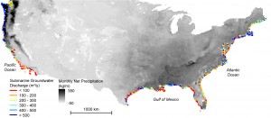
A map shows below-ground land-to-sea water transfers along the coast of the continental United States. Blue areas have greater flow than red areas. (Credit: The Ohio State University/NASA-JPL-Caltech)
Coastal waters and nearshore groundwater supplies along more than a fifth of coastlines in the contiguous United States are vulnerable to contamination from previously hidden underground transfers of water between the oceans and land. This revelation was found in a study recently published in the journal Science by researchers at The Ohio State University and NASA’s Jet Propulsion Laboratory.
The study resulted in the first-ever map of the underground flows that connect fresh groundwater beneath the contiguous United States and seawater in the surrounding oceans, highlighting areas most vulnerable to degraded water quality from these flows now and in the future.
The researchers combined U.S. topographic data and NASA climate models to identify key inland regions that contribute groundwater and contaminants to the coast. They examined rainfall, evaporation rates and the amount of known surface runoff to calculate the missing portion of water that was running out below ground, then melded those results with terrain and land-use data to identify where the water ended up.
