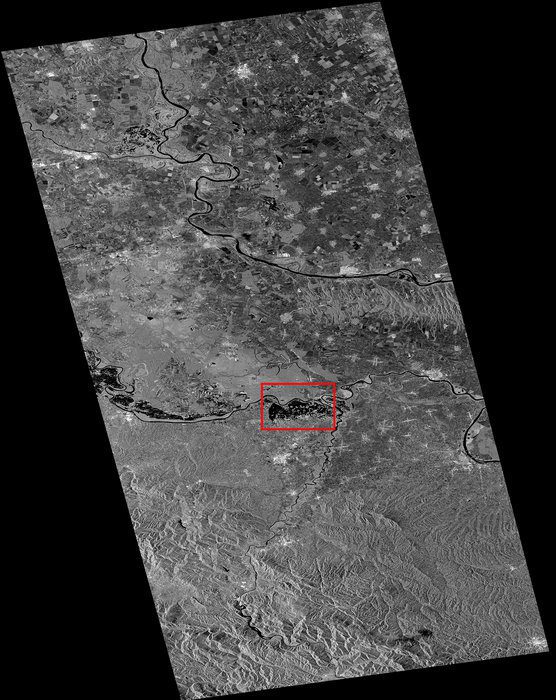
This radar image is a Sentinel-1A satellite scan from May 24, 2014, over parts of Serbia, Bosnia-Herzegovina and Croatia. The area used for the flood delineation mapping under the Copernicus EMS is indicated in the red box.
Although not yet operational, the European Space Agency's new Sentinel-1A satellite has provided radar data for mapping the floods in Bosnia and Herzegovina.
Heavy rainfall leading to widespread flooding and landslides has hit large parts of the Balkans, killing dozens of people and leaving hundreds of thousands displaced. Jan Kucera of the European Commission's Joint Research Centre is supervising the technical aspect of the Copernicus Emergency Management Service (EMS). While mapping the flooding in northeastern Bosnia and Herzegovina, the European Space Agency delivered a radar scan from Sentinel-1A.
I had a first look and discovered that we were missing an important flooded area visible in the middle of the image, said Kucera. In emergency situations like these, it is important that we optimize all the available data to produce better maps for disaster relief efforts.
Although the radar on Sentinel-1A is still being calibrated, the new information could be integrated into the Copernicus EMS flood maps of the Sava River in the Balatun area in Bosnia and Herzegovina.
The radar on Sentinel-1A is able to see through clouds, rain and in darkness, making it particularly useful for monitoring floods. Images acquired before and after a flood offer immediate information on the extent of inundation and support assessments of property and environmental damage. Sentinel-1A was launched on April 3, 2014, and is the first in a fleet of Sentinel satellites developed for Europe's Copernicus environmental monitoring program.
Image courtesy of European Space Agency.
