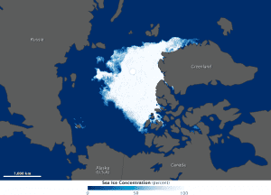
This 2012 map was compiled from observations by the Advanced Microwave Scanning Radiometer 2 sensor on the Global Change Observation Mission 1st-Water (Shizuku) satellite, which is operated by the Japan Aerospace Exploration Agency.
In August and September 2012, sea ice covered less of the Arctic Ocean than at any other time since at least 1979, when the first reliable satellite measurements began.
The National Snow and Ice Data Center (NSIDC) and NASA announced in mid-September that the extent of Arctic sea ice had dropped to 3.41 million square kilometers (1.32 million square miles)”well below the previous record of 4.17 million square kilometers (1.61 million square miles) set in 2007.

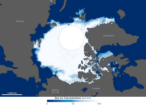
This 1984 image was made from observations by the Scanning Multichannel Microwave Radiometer on the Nimbus-7 satellite. The sea ice has a blocky appearance because that sensor had coarser resolution.
The accompanying maps compare the Arctic ice minimum extents from 2012 and 1984. According to NSIDC, the average minimum extent for 1979“2000 was 6.70 million square kilometers (2.59 million square miles). The 1984 minimum was roughly that amount, while the minimum ice extent in 2012 was about half the average.
Images courtesy of NASA.

