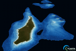
A satellite-derived bathymetry dataset is shown at a resolution of 10 meters.
TCarta delivered satellite-derived bathymetry (SDB) to Total SA, one of the world's largest oil and gas producers, which will use the water-depth data for preparing seismic survey works off the coast of Myanmar.
The SDB dataset was generated by digitally extracting accurate water depth measurements from multispectral imagery acquired by the European Space Agency's Sentinel-2 satellite. The resulting bathymetric data had a point spacing of 10 meters with measurements to a depth of 15 meters. The deliverable covered a 30-square-kilometer area around Preparis Island in the Bay of Bengal.
Total contracted with TCarta for the Preparis Island project following a benchmark study that also generated high-quality bathymetric data from Sentinel-2 imagery.
