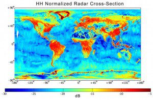
An SMAP radar image shows data acquired from March 31-April 3, 2015. Weaker radar signals (blues) reflect low soil moisture or lack of vegetation, such as in deserts. Strong radar signals (reds) are seen in forests. (Credit: NASA/JPL-CALTECH/GSFC)
Aaron Berg, a University of Guelph geography professor using a NASA satellite to study global soil-moisture levels, received a $280,000 boost from the Canadian Space Agency. Berg's research project was one of five across Canada to receive funding. (Listen to Professor Berg discuss his research with CBC radio).
Berg and his team are using information gathered by NASA's Soil Moisture Active Passive (SMAP) satellite to help farmers and meteorologists better-predict crop yields, floods, droughts and seasonal weather forecasts. The satellite was launched in January 2015 and uses passive microwave radiometer and radar to determine soil-moisture levels. It travels from North to South Pole, orbiting Earth every 98 minutes and looking into the outer five centimeters of soil.
Farmers will be better able to predict yields of crops, or the data can provide early warning of conditions conducive to an explosion of pests; in either case, farmers can make informed decisions, said Berg.

