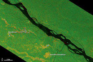
UAVSAR captured the data for this image on March 17, 2013, as the instrument was being flown on a NASA Gulfstream C-20A aircraft. The scene shows forested wetlands around the Napo River in Ecuador and Peru at a resolution of 6 meters (20 feet) per pixel.
Remote sensing specialists at NASA's Jet Propulsion Laboratory have been using a new sensor that relies on microwaves to peek under the blanket of white (clouds) and green (leaves).

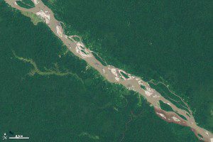
This image of the Napo River in Ecuador and Peru, acquired by the Enhanced Thematic Mapper Plus (ETM+) sensor on the Landsat 7 satellite, shows roughly the same area as the UAVSAR image in natural color on a rare cloud-free day in 2002. The resolution of the image is 30 meters per pixel.
Tropical forests and wetlands are some of the most compelling and important areas of study for Earth scientists and ecologists, but they're notoriously hard to penetrate on foot or from the air.
There are vast portions of forest within the Amazon River basin that experience seasonal or semi-permanent flooding, and many of those areas are remote, with no roads or navigable rivers, said Bruce Chapman, NASA remote sensing specialist. Flooding is difficult to reliably detect with optical imagery because the forest canopy obscures the view. Another problem is clouds, especially during the rainy season.
Chapman and his colleagues are experimenting with Uninhibited Aerial Vehicle Synthetic Aperture Radar (UAVSAR), which relies on microwaves instead of visible light to make images of the land surface. UAVSAR's radar waves, which have a wavelength of more than 20 centimeters (8 inches), can easily penetrate the tree canopy and the cloud cover. That means researchers can acquire data during any season, rainy or dry.
Image courtesy of NASA.

