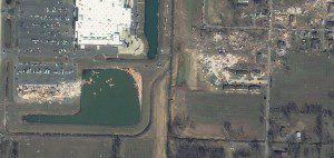
An Ikonos image clearly shows the tornado's path from west to east, as well as major damage to buildings, structures and other facilities.
This one-meter resolution image of Harrisburg, Ill., was collected by GeoEye's Ikonos satellite on March 1, 2012, just one day after a Level 4 tornado touched down on Feb. 29, 2012. The storm system was so strong and vast that as many as 34 million people were in the “high” or “moderate” risk categories for severe weather on March 1, according to meteorologist Harold Brooks of the National Severe Storms Laboratory in Norman, Okla. To date, severe storms have caused 55 confirmed fatalities in the United States in 2012.
Image courtesy of GeoEye.
Source: GeoEye

