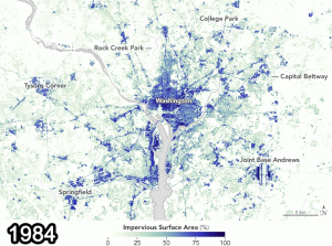
A map based on Landsat satellite data shows the concentration of impervious surfaces in the Washington, D.C., region in 1984 and 2010. (Credit: NASA)
A study recently published in the Remote Sensing of Environment journal used Landsat data from 1984 and 2010 to show how paved surfaces in the Washington, D.C., area have increased dramatically.
According to the paper written by University of Maryland researchers, Extending an established procedure for deriving annual, fractional estimates of impervious surface cover (ISC) from per-pixel Landsat composites, we propose a new post-classification methodology that characterizes ISC change as a continuous field in space and time.
Researchers hope the studies make it clear that satellite programs such as Landsat can be used to reliably map the history of urban development.
The pace of development”9 to 11 square kilometers per year”was striking. If we assume, conservatively, that the depth of impervious cover is about one-tenth of a meter, then that equals one million cubic meters of pavement, buildings and the like every year for nearly three decades, said Joseph Sexton, one of the University of Maryland scientists who conducted the research.

