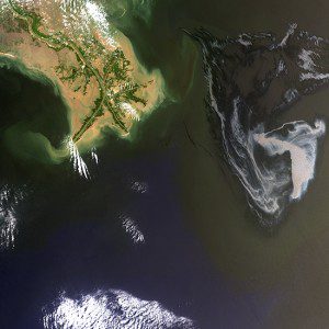
Landsat 7 imagery captured on May 1, 2010, shows the extent of an oil slick resulting from the Deepwater Horizon oil rig explosion in the Gulf of Mexico.
Launched on April 15, 1999, the long-lived Landsat 7 mission celebrates a continuous, unbiased record of changes for 15 years and adds to the Landsat program's 42-year legacy.
Landsat 7 provides a worldwide audience with objective views, both current and historical, of events and trends across the global landscape. Landsat data can be used to detect and monitor urban growth, forestry practices, the extent of floods, wildfire burn acreage, major natural or human-caused disasters and many other important changes in land-surface conditions.
Landsat 7's remarkable longevity has been vital to most Landsat data users who require frequent imaging of specific areas for land and resource management. For example, water resource managers in western U.S. states need Landsat's unique combination of thermal and vegetation condition readings at field scale to estimate water use more efficiently for crop irrigation”typically the major source of water consumption in these arid regions
Combined with Landsat 8, Landsat 7 ensures the collection of images across the entire United States every eight days (clouds permitting) and enables the collection of critical global imagery sets on a seasonal basis. Working in tandem, Landsat 7 and Landsat 8 together collect nearly 1,000 images daily, almost double the amount of data collected when Landsat 5 and 7 were operating together. This increased data collection benefits all Landsat applications, especially in persistently cloudy areas (e.g., humid tropics and high latitudes) where multiple imaging attempts are essential.
A mechanical failure onboard Landsat 7 in 2003 reduces the amount of data in each scene by 22 percent. However, this loss doesn't affect the quality or usefulness of the remaining data. Many users simply treat the blank areas of each scene as if they were obscured by clouds. Landsat customers, especially those with agricultural interests who require 8-day repeat data collection, have a strong motivation to use Landsat 7 data even with the 22 percent loss per scene.
Barring the failure of any key spacecraft component, the remaining fuel on Landsat 7 is expected to permit imaging operations through 2017. NASA and the U.S. Geological Survey are working together on a plan to ensure long-term continuity of land imaging operations while addressing the near-term need to replace Landsat 7.
Image courtesy of U.S. Geological Survey.

