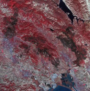
 As firefighters continue to work toward full containment of the rash of wildfires burning in Northern California, a new image from the Advanced Spaceborne Thermal Emission and Reflection Radiometer (ASTER) instrument on NASA’s Terra satellite shows the growing fire scar on the landscape. In this ASTER image acquired Oct. 21, 2017, vegetation is red, while burned areas appear dark gray. The image covers an area of 38 by 39 miles (60.5 by 63 kilometers) and is located near 38.5 degrees north, 122.4 degrees west.
Photo credit: NASA/ASTER
