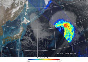
The GPM Microwave Imager shows precipitation across a broad swath of the atmosphere. The colors depict the rain rate; red areas indicate heavy rainfall, while yellow and blue indicate less intense rainfall. The blue areas in the upper left indicate falling snow. GPM has the first satellite sensors specifically designed to measure falling snow and light rainfall.
NASA and the Japan Aerospace Exploration Agency (JAXA) released the first images from their new Earth-observing satellite, the Global Precipitation Measurement (GPM) Core Observatory.
Launched on Feb. 27, 2014, the new mission will study rain and snow from the tropics to the southern edge of the polar regions. GPM also will anchor an international network of satellites that can make global precipitation observations roughly every three hours.
GPM's unique capability to monitor all types of precipitation is apparent in these images, which show precipitation inside an extratropical cyclone in the northwest Pacific Ocean on March 10, 2014. Captured approximately 1,700 kilometers (1,055 miles) east of Japan, the images include the first space-based radar view of an extratropical cyclone.
It was really exciting to see this high-quality GPM data for the first time, said project scientist Gail Skofronick-Jackson. I knew we had entered a new era in measuring precipitation from space. We can now measure global precipitation of all types, from light drizzle to heavy downpours to falling snow.
Image courtesy of NASA/JAXA.

