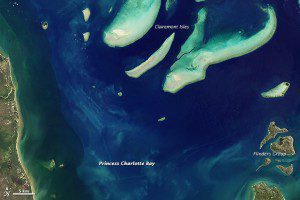
This image of Princess Charlotte Bay, which lies along the east coast of Queensland's Cape York Peninsula in Australia, was acquired by Landsat 8's Operational Land Imager on April 20, 2013. The scene shows Claremont Isles National Park, where coastal waters are protected as part of the Great Barrier Reef World Heritage Site.
Landsat satellites were designed to gather images of Earth's land surfaces, but during the last four decades, the satellites also have been useful for observing blue parts of the planet.
Landsat has particularly enriched the study of coral reefs. Scientists used earlier generations of Landsats to create a global image library of coral reefs. They also have been able to do time-series assessments of the health of some reefs.
For instance, researchers used 18 years of Landsat data to show a decline in the health of reef habitat across roughly 68 percent of the Florida Keys National Marine Sanctuary. Satellite images also can detect signs of trawling and other fishing activities that can be harmful to reefs.
The remote location and massive size of reefs make them an ideal subject for Landsat remote sensing, said Phillip Dustan, a marine biologist at the College of Charleston (South Carolina) who has worked with Landsat to map reefs around the world. Reef management benefits from satellite imagery through mapping, change analysis and threat assessment. While a single image can be used to provide mapping data, the long-term data set provided by Landsat makes for powerful time series of images that can probe the dynamics of ecological change.
Image courtesy of NASA.

