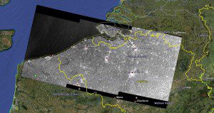
A simulated Sentinel-1 interferometric wide-swath mode satellite image over the Netherlands using archived Envisat radar data is overlaid on Google Earth.
Users with a wide range of satellite data needs, from mapping sea ice and tracking maritime traffic to monitoring geohazards, anticipate the European Space Agency's coming Sentinel-1 launch.
The agency is helping users get ahead of the game by offering test data and simulated images. To be launched later this year, Sentinel-1 is the first of five satellite missions dedicated to supplying a stream of data for Europe's Global Monitoring for Environment and Security (GMES) Copernicus program.
This particular satellite will provide timely high-quality radar images of our planet's surface to support European operational services that use Earth observation data in areas such as emergency response, marine and land monitoring, civil security and climate studies.
Getting ready for using Sentinel data is a complex task. The new data format and information structure, the increased data volume, the expected data quality and sensor characteristics all mean that users have to develop or update processing facilities before the launch.
An important step forward in this respect is the availability of simulated products and documentation to users. The European Space Agency is responding to these needs in two ways. First, the agency just released a sample of Sentinel-1 simulated user products and associated format and product definition documents to GMES users.
In addition, the agency is planning a further distribution to all potential users in the coming weeks. To complement this initial release of test data, the agency is, in parallel, simulating Sentinel-1 acquisitions from space using Canada's Radarsat-2 satellite.
Image courtesy of European Space Agency.

