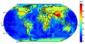
This map shows the global Moho, based on data from the GOCE satellite. Moho is the boundary between Earth's crust and mantle.
The GOCE Exploitation for Moho Modelling and Applications project”or GEMMA”has now generated the first global high-resolution map of the boundary between Earth's crust and mantle based on data from the GOCE satellite. GOCE measures the gravity field and models the geoid with unprecedented accuracy to advance our knowledge of ocean circulation, which plays a crucial role in energy exchanges around the globe, sea-level change and Earth interior processes.
Image courtesy of the GEMMA project.

