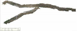
A composite image of the intersection of the flooded St Vrain River and Left Hand Creek in Longmont, Colo., was compiled from imagery acquired by an unmanned aircraft system flown by volunteers from Falcon UAV.
Volunteers from Falcon UAV say they were providing mapping services to local officials when the Federal Emergency Management Agency (FEMA) said they would be arrested if they continued flying.
In the wake of the recent floods in Colorado, the volunteers spent Sept. 11-13 providing aerial services to the Boulder County Emergency Operations Center (EOC) and the Incident Management Team (IMT). On Sept. 12, while all National Guard aircraft were grounded due to weather, the volunteers were proud to have the only aircraft that was able to fly to support flood efforts in Lyons.
Sept. 13 brought a reprieve in the weather, and the volunteers were able to get a perfect flight off in the town of Longmont to capture aerial imagery for damage assessment at the intersection of the overflowing St. Vrain River and equally inundated Left Hand Creek. In less than an hour the imagery was processed and provided to the Boulder EOC. Just as the volunteers were off to another damage assessment in Lyons, they were requested to stand down for National Guard helicopters now supporting evacuation efforts.
Early Sept. 14, the volunteers were heading to Lyons to complete a damage assessment mapping flight when they received a call from their Boulder EOC point of contact who notified them that FEMA had taken over operations and denied the volunteers' request to fly drones. In fact, FEMA officials said that anyone flying drones would be arrested.
Image courtesy of Falcon UAV.

