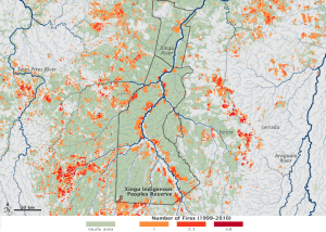
A new Earth observation satellite sensor technique has made it possible for NASA Scientist Doug Morton and his colleagues to map the distribution of understory fires across the entire southern Amazon basin for the first time. Morton found that understory forest fires burned more than 85,500 square kilometers (33,000 square miles), or 2.8 percent of the forest, between 1999 and 2010.
A NASA scientist, employing a breakthrough satellite sensor technique to track understory fires, poses the question: Will we see a gradual transition from [Amazon] forest to savanna over time?
When most people think of the Amazon rainforest, they envision a vast expanse of green jungle, dripping with moisture year round. Some parts of the Amazon do receive relentless rain, but other regions have a distinct dry season when little or no rain falls.
The southeastern Amazon, in the Brazilian states of Mato Grosso and Pará, has a four- to five-month dry season that limits rains to a trickle. Lush vegetation survives by sending roots up to 10 meters (30 feet) into the ground. Ecologists worry that as climate change brings hotter, drier conditions to the region, the southern edge of the Amazon could easily transition from forest to tropical savanna.
Then there are the fires. Satellite and ground observations of the forest edge show evidence of what ecologists call understory fires”low-intensity blazes that creep along the leaf cover on the forest floor, but never get hot enough to burn up through the canopy.
Since the fires remain beneath the canopy, NASA satellites designed to monitor fire rarely detect understory fires (unlike those that release more energy, such as deforestation or agricultural management fires). But satellites can sense the subtle changes in the forest canopy in the wake of these understory fires, as the damaged vegetation slowly dies and new trees grow back.
Distinguishing between understory fire damage and other types of forest disturbance”such as selective logging and deforestation for agriculture”isn't straightforward with satellite imagery, according to NASA Scientist Doug Morton. In the last few years, Morton has worked out a new technique based on data from the Moderate Resolution Imaging Spectroradiometer sensor that makes it easier to distinguish understory fires from similar-looking forest disturbances.
Image courtesy of NASA.

