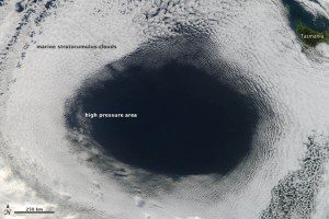
A NASA scientist referred to this high-pressure phenomenon as an anti-storm because it creates a large circle of clear weather.
High-pressure weather systems often bring fair weather and relatively clear skies. In early June 2012, a high off the coast of Tasmania did just that”and in spectacular fashion.
The Moderate Resolution Spectroradiometer (MODIS) sensor on NASA's Aqua satellite acquired this view of a hole in a cloud formation at 3 p.m. local time onJune 5, 2012. The weather system over the Great Australian Bight cut out the oval-shaped hole from a blanket of marine stratocumulus clouds.
The cloud hole, with a diameter that stretched as far as 1,000 kilometers (620 miles) across, was caused by sinking air associated with an area of high pressure near the surface. Globally, the average sea-level pressure is about 1013 millibars; at the center of this high, pressures topped 1,040 millibars.
Sea-level pressure maps showed that the shape of the cloud hole matched the shape of the high-pressure area. However, the center of high pressure and the cloud hole didn’t match precisely; the center of the high was near the western edge of the clear area, about 100 kilometers from the cloud edge.

