Bruchsal, Germany, March 28, 2018 – The Swiss once again surpass the Germans and Austrians when it comes to purchasing power. But the available net income within each of these countries also varies markedly. None of the federal states or cantons encompassing the...
Release of New Accurate and Recent Global Imagery Mosaic
 Clermont-Ferrand, France – PlanetObserver, provider of geospatial data for civil and military solutions, announces the release of the most up-to-date global mosaic processed with recent and cloud-free satellite imagery. With an unmatched 10-meter resolution at...
OGC Requests Responses to a Survey Regarding Potential Professional Certification Program
The Open Geospatial Consortium (OGC) is considering developing a Professional Certification program. The program would allow individuals to achieve certification that confirms their competency in specific OGC standards. The program would therefore focus primarily on...
AgEagle Aerial Systems Closes Merger with EnerJex; To Initiate Trading on NYSE as UAVS
Neodesha, KS - AgEagle Aerial Systems, Inc. (NYSE American: UAVS), an aerial drone imagery collection and analytics company, today announced that it has closed its merger transaction with EnerJex Resources, Inc. (NYSE American: ENRJ), pursuant to which AgEagle becomes...
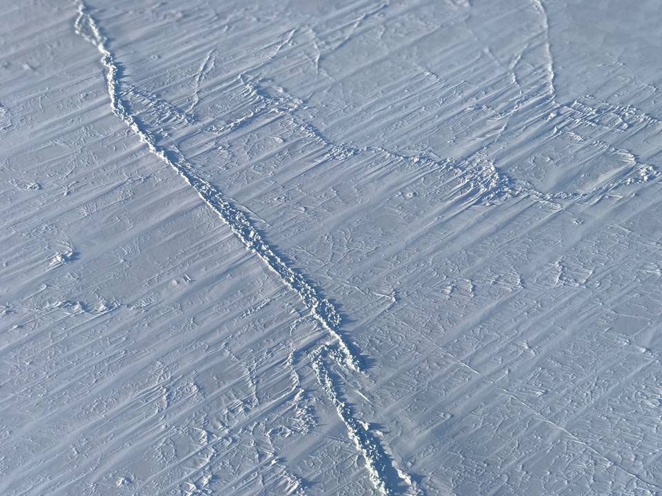
Arctic Wintertime Sea Ice Extent Among Lowest On Record
Sea ice in the Arctic grew to its annual maximum extent on March 17, 2018, and joined 2015, 2016 and 2017 as the four lowest maximum extents on record, according to scientists at the NASA-supported National Snow and Ice Data Center (NSIDC) and NASA.
MDA to Provide RADARSAT-2 Information to Meet Critical and Complex Challenges for Land and Maritime Monitoring
RICHMOND, BC - MDA, a Maxar Technologies company (formerly MacDonald, Dettwiler and Associates Ltd.), (NYSE: MAXR; TSX: MAXR), announced today it has recently signed multiple geospatial-related contracts based on RADARSAT-2 satellite information. RADARSAT-2 Synthetic...
Spacecom Selects Maxar Technologies’ SSL to Build AMOS-8 Communications Satellite with Advanced Capabilities
PALO ALTO, CA and TEL AVIV, Israel - Spacecom (TASE: SCC), operator of the AMOS satellite fleet, today announced it has chosen SSL, a Maxar Technologies company (formerly MacDonald, Dettwiler and Associates Ltd.), (NYSE: MAXR; TSX: MAXR) to build its AMOS-8 advanced...
senseFly Takes Drone Flight Plannng & Management to Next Level with Release of eMotion 3.5
Cheseaux-sur-Lausanne, Switzerland: senseFly, the world’s first-choice producer of professional mapping drones, and a Parrot Group company, today released a groundbreaking new version of its industry-acclaimed flight and data management software, eMotion. ...
Esri Location Intelligence Empowers Innovation at FirstNet Hackathon
REDLANDS, Calif. — Esri, the global leader in spatial analytics, today announced that it will sponsor the FirstNet Public Safety Hackathon in San Francisco, March 23–24. FirstNet is hosting the hackathon to drive the development of public safety focused mobile...
GRSG Chairman is Coming Up Trumps for the Geological Society
The Chairman of the Geological Remote Sensing Group (GRSG) Charlotte Bishop, will be giving the next Geological Society Public Lecture at Burlington House on London’s Piccadilly once in the afternoon and again in the evening of Wednesday 28th March.  Under the...
