SAN FRANCISCO - DroneDeploy, a drone software platform with the largest drone data repository in the world, released its 2018 annual Commercial Drone Industry Trends Report. The report quantifies the impact of aerial insights across several industries and cements...
Orbit GT Exhibits and Showcases Newest 3D Mapping Portfolio at SPAR 3D & AEC, Anaheim, CA
Orbit GT will exhibit at the joint SPAR 3D and AEC conference Anaheim, CA. “We’re really looking forward to this joint SPAR 3D and AEC event. There’s a lot to show as new features have been released in our 18.1 desktop products, and very interesting...
Kongsberg Geospatial Announces Official Release of TerraLens 9 Geospatial SDK
Ottawa, CA: Kongsberg Geospatial Ltd., an Ottawa-based developer of geospatial visualisation software, announced today the official release of TerraLens 9.0, the latest version of their real-time, high performance, software development toolkit for geospatial...
Maxar Technologies' DigitalGlobe Releases GBDX Notebooks Commercially, Further Accelerating Machine Learning Innovation
WESTMINSTER, Colo. - DigitalGlobe, a Maxar Technologies company (formerly MacDonald, Dettwiler and Associates Ltd.) (NYSE: MAXR; TSX: MAXR), announced today the commercial release of GBDX Notebooks, allowing customers to easily extract valuable insight they want from...
Tobii Pro Brings Eye Tracking Analytics to Virtual Reality
Tobii Pro, the global leader in eye-tracking research solutions, announces a new analytical tool: Tobii Pro VR Analytics that allows eye-tracking studies to be conducted within 3D virtual reality (VR) environments. The tool embeds into Unity environments and comes...
NavVis to Present M6 Indoor Mobile Mapping System at SPAR 3D
NavVis, a global leader in mobile indoor mapping, visualization, and navigation, will present NavVis M6, the recently launched next-generation indoor mobile mapping system, at SPAR 3D. SPAR 3D is the premier international event for the application of 3D technology....
Esri Announces Release of Sentinel-2 Image Services
REDLANDS, Calif. — Esri, the global leader in spatial analytics, today announced that it is releasing Sentinel-2 Image Services to all Esri users for no additional cost. Sentinel-2 is an Earth Observation Satellite that provides multi-spectral imagery for any...
Siemens to Provide Electric Propulsion Motor for Bye Aerospace’s Sun Flyer 2
Bye Aerospace and Siemens will collaborate on future development of Bye Aerospace’s Sun Flyer 2. “We are pleased to announce an agreement with Siemens to provide the electric propulsion motor and inverter for the Sun Flyer program,†said George Bye, CEO of Bye...
GeoSLAM to Demo Fast, Easy and Versatile 3D Mobile Laser Scanning at 2018 SPAR3D Conference
ANAHEIM, California, USA – GeoSLAM will demonstrate the speed, simplicity and versatility of 3D mobile data collection next week at the 2018 SPAR3D Expo & Conference. The technology firm will preview its latest product – the ZEB REVO RT handheld laser scanner...
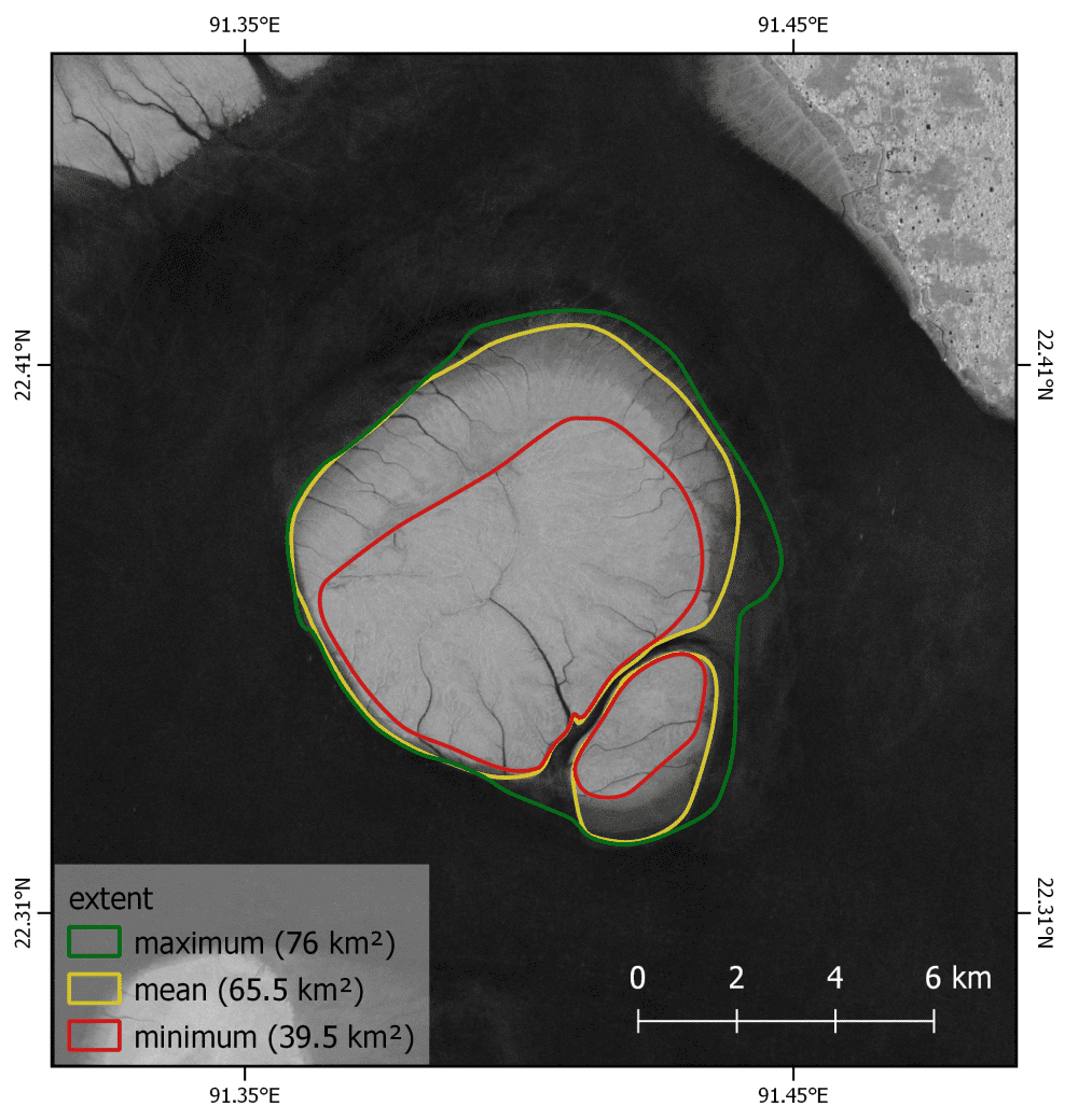
Satellites Warn of Refugee Island Flood Risk
With the Bangladesh government proposing a vulnerable low-lying island as a relocation site for thousands, Sentinel-1 satellite data have shown how unsuitable this site would be.
