CAMBRIDGE, Mass. - NSR’s Big Data Analytics via Satellite, 2nd Edition report, published today, finds downstream Big Data solutions continue on a sustained growth path over the next decade, largely driven by Earth Observation and M2M/IoT applications in several key...
Jim Maser Joins Aerojet Rocketdyne as Senior Vice President, Space Business Unit
SACRAMENTO, Calif. - Aerojet Rocketdyne announced today that Jim Maser will join the company on Aug. 13 as senior vice president of the Space Business Unit, reporting directly to CEO and President Eileen Drake. In this role, Maser will oversee all NASA programs,...
3D Laser Mapping Ltd and GeoSLAM Ltd Merge, Creating a Global Market Leader in Mapping and Monitoring
Nottingham, England - Leading UK laser scanning and monitoring companies’ 3D Laser Mapping Ltd and GeoSLAM Ltd have merged to create one of the world’s most innovative mobile mapping and monitoring technology providers. 3D Laser Mapping is a world leading...
University of Tennessee, Knoxville Launches Concept3D Interactive Map and Virtual Tour Platform
DENVER – Concept3D, a leader in creating immersive online experiences with 3D modeling, interactive maps and virtual tour software, today announced that The University of Tennessee, Knoxville is the latest major university to launch on the Concept3D platform. ...
Esri Enters into Memorandum of Understanding with World Bank
Redlands, California—Esri, the global leader in location intelligence, today announced that it has entered into a memorandum of understanding (MOU) with the World Bank, an international organization with the mission to reduce global poverty. Under the agreement,...
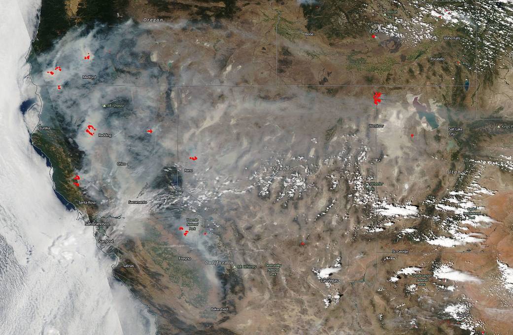
NASA Satellite Shows California Shrouded in Smoke
On July 29, 2018, NASA's Aqua satellite captured this natural-color image of the fires in California and the resultant smoke that has shrouded the state and swept eastward as far as Salt Lake City and still moving.
Copernicus Accelerator is Looking for High-level Professionals as Mentors: Call for Experienced Mentors
The 2018 Copernicus Accelerator, Europe’s Earth observation (EO) business coaching programme, is looking for mentors to pass on their knowledge and experience to 50 entrepreneurs and start-ups. Registrations are possible until 17.09.2018 at accelerator.copernicus.eu...
ARC Research Indicates Geographic Information Systems are Moving to the Cloud
DEDHAM, Mass.- New ARC Advisory Group research on the geographic information system (GIS) market reveals that GIS technology, which was once considered highly specialized, is now moving into the realm of mainstream information technology (IT). One indicator of this...
Sphere Drones to Offer Microdrones UAV Solutions
Rome, NY - Sphere Drones, a leading Australian provider of drone solutions for commercial applications, will become the newest distributor of Microdrones fully-integrated systems. Darren Wilkinson, Sales Manager for Microdrones, explains “Sphere Drones is trusted...
Thales Alenia Space and Maxar Technologies' SSL Form Consortium to Further Design and Develop Telesat's LEO Satellite Constellation
CANNES, France and WESTMINSTER, Colo. - July 30, 2018 - Thales Alenia Space, a Joint Venture between Thales (67 %) and Leonardo (33 %), and SSL, a Maxar Technologies company (NYSE: MAXR; TSX: MAXR), have signed a consortium agreement to pursue the development and...
