Montreal, Canada – SimActive Inc., a world-leading developer of photogrammetry software, is proud to announce new features to improve volumetric calculation. Correlator3D™ now has integrated tools for users to generate precise statistics on mining activities....
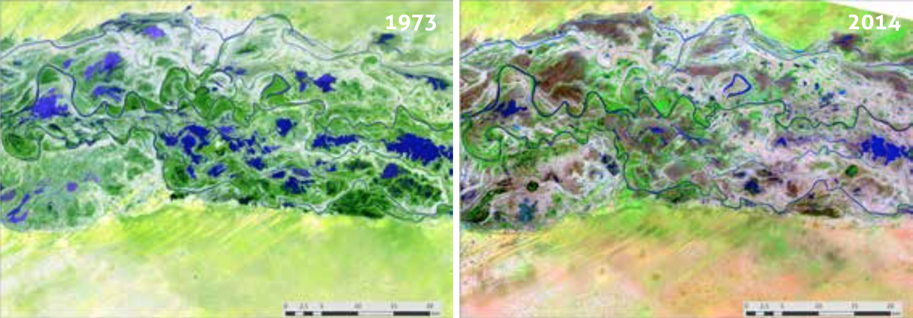
Degradation of Wetlands Contributes to Social Instability and Insecurity
During Stockholm World Water Week, Wetlands International is leading the Connecting water peace and security through ecosystems event, calling on governments to recognize the role of wetlands systems in maintaining peace and security by supplying water and food as well as sustaining human health and livelihoods.
U.S. Air Force’s First Advanced GPS III Satellite Shipped To Cape Canaveral For Launch
CAPE CANAVERAL, Fla.-Â The first of the U.S. Air Force's advanced new, higher-power, harder-to-jam GPS III satellites is making its way to the launch pad. On August 20, Lockheed Martin (NYSE : LMT ) shipped the U.S. Air Force's first GPS III space vehicle (GPS III...
Panzura Solves $68B Multi-cloud Data Management Puzzle With Launch of Vizion.ai SaaS Platform
CAMPBELL, Calif. - Panzura, a leader in multi-cloud file services and data management, today announced the launch of its new Vizion.ai SaaS platform for multi-cloud data management. Vizion.ai delivers a single, unified vision of data across the enterprise and provides...
US Electrodynamics Adds New Walton De-Ice Systems for its Satellite Earth Station Antennas
AMSTERDAM, the Netherlands - IBC 2018 Amsterdam — Walton De-Ice (www.de-ice.com), the world’s leading designer and manufacturer of satellite earth station antenna (ESA) weather protection solutions, announced that US Electrodynamics, Inc. (USEI), a major US...
Esri Workbook Teaches How to Plan, Develop, and Present a GIS Project
REDLANDS, Calif. — Esri, the global leader in spatial analytics, today announced the publication of Understanding GIS: An ArcGIS Pro Project Workbook, Fourth Edition. The workbook instructs readers on how to complete a geographic information system (GIS) project...
SkySpecs – Leader in Automated Drone Inspections & Analytics Software – Announces the Opening of New Office in Amsterdam
ANN ARBOR, Mich.,-Â SkySpecs, the award-winning provider of robotics solutions for the wind energy industry, today announces the opening of a new office in Amsterdam, Netherlands. SkySpecs has been working with leading customers in Europe since 2017 and plans to...
PolarPro Brings DJI Mavic 2 Filter Essentials to Market
COSTA MESA, Calif. - PolarPro, a California manufacturer of camera filters, continues to solidify themselves as an industry leader in premium camera filter design. As DJI continues to expand upon its popular Mavic series with today's release of the Mavic 2 Pro and...
DJI Introduces Mavic 2 Pro And Mavic 2 Zoom: A New Era For Camera Drones
NEW YORK - DJI, the world's leader in civilian drones and aerial imaging technology, today introduced a new era for camera drones with two additions to its iconic Mavic series: Mavic 2 Pro, the world's first drone with an integrated Hasselblad camera, and Mavic 2...
ESA's Aeolus Wind Sensing Satellite Successfully Launched from Kourou
Kourou - Aeolus, the European Space Agency’s wind sensing satellite, built by Airbus, has been successfully launched from Kourou, French Guiana. The satellite will now undergo a series of tests in its operational orbit at 320km before beginning operations. Built...
