UNIONDALE, N.Y.- In order to further improve and advance Long Island's electric system, PSEG Long Island and ULC Robotics, a leading technology company based in Hauppauge, are deploying unmanned aerial vehicles (UAV) – or drones – to conduct the utility's...
Airbus Presents New and Innovative Space Solutions at the IAC
Bremen - During the 69th International Astronautical Congress from 1-5 October 2018, Airbus will present its latest innovations and major space projects. As one of the main sponsors of the world's largest space congress, Airbus will also actively participate with a...
Juniper Systems Unveils New Cedar CP3 Rugged Smartphone
BIRMINGHAM, United Kingdom - Juniper Systems Limited today announced the release of its newest Cedarâ„¢ device, the Cedar CP3â„¢ Rugged Smartphone. The rugged smartphone arrives two years after its predecessor, the CT5â„¢ Rugged Smartphone, bringing massive upgrades...
The Ocean Cleanup Chooses Iridium
MCLEAN, Va.– Iridium Communications Inc. (NASDAQ:IRDM) announced today that it has been selected as the preferred provider of satellite communications services for The Ocean Cleanup , the non-profit organization deploying advanced technologies to rid the world’s...
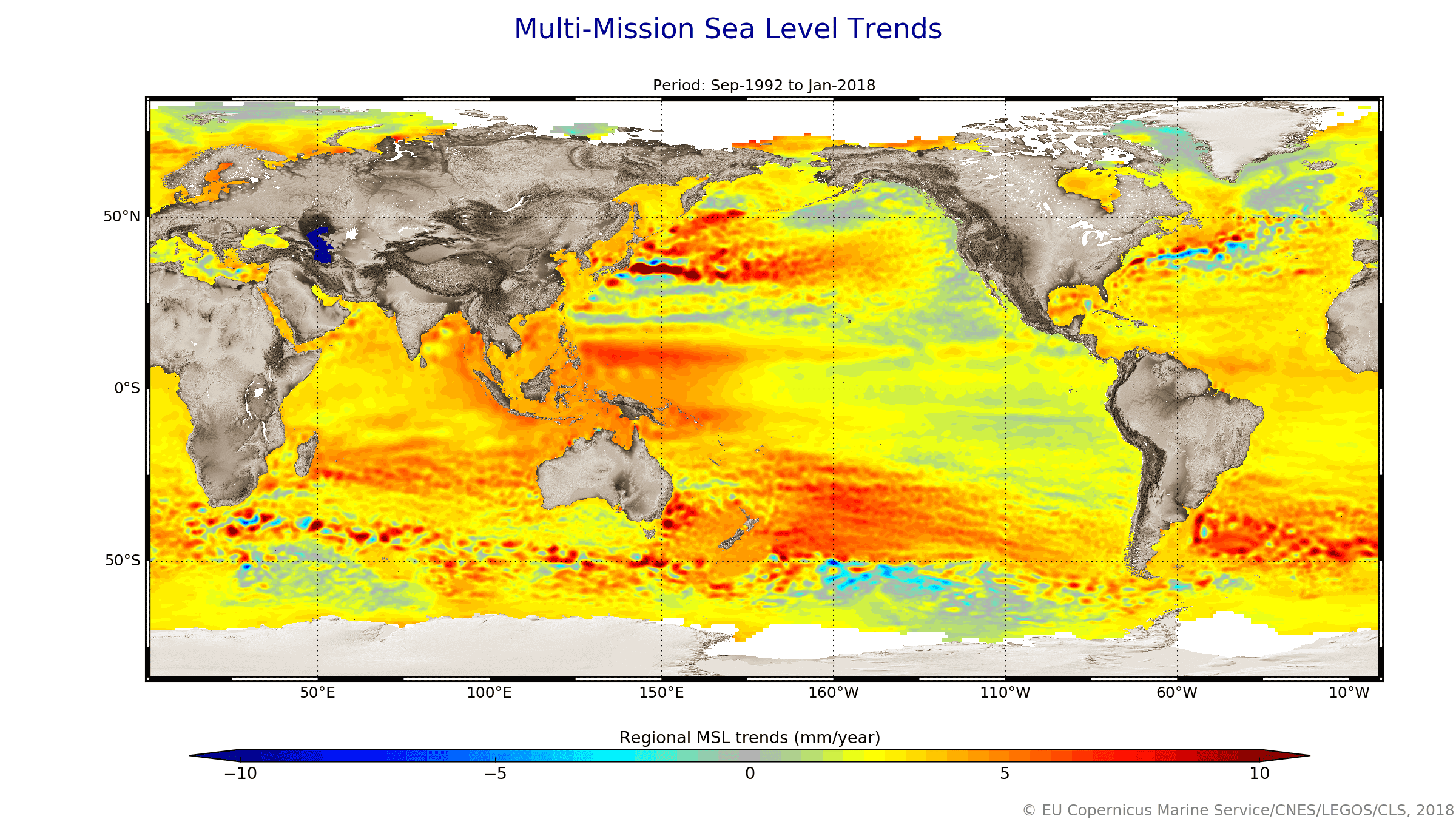
Spotlight on Sea-Level Rise
Scientists recently gathered in the Azores to share findings on how satellites have revealed changes in the height of the sea, ice, inland bodies of water and more. Of concern to all is the fact that global sea level has not only been rising steadily over the last 25 years, but recently it is rising at a much faster rate.
Mobile Mapping Market size worth over $40bn by 2024
Mobile Mapping Market size is set to be over USD 40 billion by 2024; according to a new research report by Global Market Insights, Inc. The mobile mapping market is propelled by the increasing adoption of mobile devices such as smartphones and tablets across the...
MAPSearch Launches New Algorithm to Simplify Solar Site Selection
TULSA, Okla.-Â ENvision, MAPSearch's online mapping platform, enables anyone to quickly locate, display, and analyze energy infrastructure using the same quality data licensed to our GIS customers. Based on a strong and growing solar market, MAPSearch created a site...
Integrated Navigation Systems by Polynesian Exploration Inc.
SAN JOSE, Calif. - Polynesian Exploration Inc. introduced today PolyNav 2000P, a high accuracy navigation solution for emerging applications such as autonomous driving and UAVs. PolyNav 2000P is designed to fully utilize the advantages of both Global Navigation...
New BlueSky GNSS Firewall From Microsemi Provides Secure, Continuous Timing Integrity in GPS-Denied Environments
ALISO VIEJO, Calif. - GPS revolutionized the world with its ability to provide accurate and cost-effective positioning, navigation and timing (PNT), yet its rapid adoption has caused critical infrastructure sectors to be overly dependent upon the satellite-based...
Sparx Systems Supports Standards Development for Intelligent Transport Systems (ITS)
Sparx Systems has entered into a collaboration with the Intelligent Transport Systems (ITS) communities in International Organization for Standardization (ISO) and European Committee for Standardization (CEN), to support the important work of standards development....
