FRANKFURT, Germany — Trimble (NASDAQ: TRMB) announced today the launch of the Trimble® Nomad® 5 handheld computer—the next generation of its rugged Nomad series of handhelds. Built for tasks such as data collection, asset management and inspections, the Nomad 5...
Trimble Inpho Software Suite Extends Photogrammetric Deliverables for Broad Range of Geospatial Applications
FRANKFURT, Germany—Trimble (NASDAQ: TRMB) announced today a new version of its Inpho office software suite for photogrammetry. The suite includes two new capabilities: MATCH-3DX software for the creation of rich 3D point clouds and true orthomosaics MATCH-3DX...
CoreSite Launches Concept3D’s Virtual Tour Platform in Virginia Data Centers
DENVER - Concept3D, (https://concept3d.com) a leader in creating immersive online experiences with 3D modeling, virtual reality (VR), interactive maps and virtual tour software, today announced that CoreSite (https://www.coresite.com) has launched the Concept3D...
Hexagon's Geospatial Division Releases M.App Enterprise 2018
NORCROSS, GA. – Hexagon’s Geospatial division announces a new version of M.App Enterprise for 2018, M.App Enterprise 16.5. This privately-hosted solution allows organizations to deploy Hexagon Smart M.Apps that dynamically address their location-based business...
Leica Geosystems Increases Efficiency with Hydrographic Survey Systems Upgrade
(Heerbrugg, Switzerland – 18 October 2018) – Leica Geosystems, part of Hexagon, announced today the availability of Leica Chiroptera 4X and Leica HawkEye 4X. The latest upgrades introduce a new bathymetric LiDAR high resolution technology that increase the...
Leica Geosystems Introduces New Generation of Manual Total Stations
(Heerbrugg, Switzerland ) – Leica Geosystems, part of Hexagon, announced today the launch of the new manual total stations, the Leica FlexLine series. Building on the FlexLine series legacy of quality, durability and low total cost of ownership, the  new Leica...
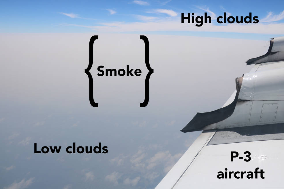
African Smoke-Cloud Connection Target of NASA Airborne Flights
Over the southeast Atlantic Ocean, a 2,000-mile-long plume of smoke from African agricultural fires meets a near-permanent cloud bank offshore.
Grand Opening of INTERGEO 2018
Frankfurt/Karlsruhe, 16 October 2018 | “Digitalisation is turning our industry upside down. We can either take note of this or play an active role in the process. INTERGEO 2018 is the place to find people who have opted for the latter and promote geodesy,...
Pointfuse Launches New Laser Scanning Software Suite at Digital Construction Week
Maidenhead, UK – Pointfuse is releasing Pointfuse 2018 a new suite of laser scanning software which includes a cloud based data processing service called Pointfuse Bolt. Designed to promote and support the practice of frequent capture of digitized ‘as built’...
Swift Navigation and Carnegie Robotics Introduce Duro Inertial
Swift Navigation, a San Francisco-based tech firm building centimeter-accurate GNSS technology and a Cloud-based Corrections Service to power a world of autonomous vehicles, and Carnegie Robotics LLC (CRL), an industry leader in reliable robotic components and...
